.jpg)
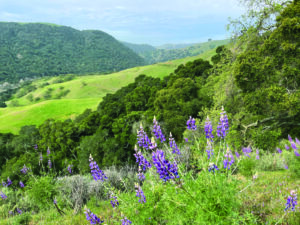
The contrast could hardly be any starker. Driving south from Antioch on Somersville Road in dense rush hour traffic, one passes busy strip malls and shopping centers. The modern four-lane highway leads through new, neatly landscaped housing developments. But just past the last turnoff, the scenery changes abruptly. The wide road becomes a narrow lane. New houses with manicured front yards give way to rolling hills dotted with colorful wildflowers amid the vivid green of the grass. It doesn’t take much more than half a mile for the transition to be complete: You’ve left sprawling suburbia behind and now find yourself in Black Diamond Mines Regional Preserve, where coyotes roam and raptors soar.
One hundred twenty years ago, you would have found the opposite contrast. Then, most of the area now covered by Pittsburg and Antioch consisted of a few ranches and acre upon acre of marshland. In today’s peaceful hills to the south, however, lay the bustling towns of Nortonville, Somersville, and Stewartville, as well as the smaller villages of West Hartley and Judsonville. Heavy machinery operated around the clock, day in and day out, and three separate railroads connected the interior with the Sacramento and San Joaquin rivers to the north.
For more than four decades, beginning in the 1860s, the Mount Diablo Coal Field was one of the Bay Area’s prime industrial centers. From the tunnels and shafts of its 12 independent coal mines, workers brought up the source of the energy that stoked the steam engines and furnaces of rapidly growing Northern California.
Today, hardly a trace of those five towns and their mining operations remains. In fact, uninitiated hikers might stroll along the 65 miles of trails at Black Diamond without realizing they are walking on ground that held the coal that powered post—Gold Rush California. The curious and observant wanderer, however, will quickly notice that human forces must have been at work in this landscape. Look down on the hills and valleys from a high vantage point, and you’ll see straight lines cutting through the slopes. These are the grades of the three railroads that transported coal to landings in Pittsburg and Antioch. In some places, where a natural dip cuts through the slope, the straight line is interrupted. It is not difficult to imagine such a gap bridged by one of the many wooden trestles that supported iron tracks more than a century ago.
Some of the trails in this 6,286-acre preserve lead through areas with elongated piles of rocks and pebbles. The darkish brown-to-black color of the dirt gives away the secret of its origin: This is waste rock, mostly shale, hauled out and dumped at the surface by miners who were after coal, some of it brought up from depths of more than 700 feet. The park is sprinkled with closed shafts—signs that below your feet run more than 200 miles of mine tunnels.
Historians are not sure when the commercial value of the coalfield north of Mount Diablo was discovered. Native Americans, and later the Spanish settlers, may have noticed the coal, because even today some seams of “black diamond” can be seen at the surface in several locations. The earliest known description is in a letter from the French consul in California, Louis Gasquet, to his superiors in 1845, in which he mentions the “abundant good quality of coal in the vicinity of San Pablo Bay.” The first well-documented discovery was in the 1850s, when rancher William C. Israel found a large outcrop of coal in a spring in Horse Haven, about six miles south of Antioch.
After Israel’s find became known, disappointed gold diggers descended on the area to seek the fortunes in coal that had eluded them in gold. Coal mining began in earnest in the 1860s and reached its peak about a decade later. By then more than a thousand miners—from Wales, Italy, Ireland, Germany, and other countries—were digging their way through two major and several smaller coal seams. The Black Diamond Vein is the thickest coalbed in the area, with a layer of minable coal up to five feet thick. The Clark Vein, about 375 feet above the Black Diamond, was much easier to reach from the surface. But it was considerably thinner—it averaged three feet and narrowed to only 18 inches in some places.
By the time major coal production came to a halt here in 1902, the miners had extracted more than 4 million tons of coal from the Mount Diablo Coal Field. That’s a small amount by today’s standards, but the haul was a major economic force in the decades after the Gold Rush.
The demise of local coal mining operations had several causes. The coal beds here dip down to the north at 30 degrees due to the uplift of Mount Diablo, so the miners had to go progressively deeper to reach the seams, until air circulation and groundwater intrusion became significant problems. The main cause, however, was the discovery of much better coal in western Washington. The Black Diamond Mining Company closed its operation in Nortonville and moved everything—miners and equipment alike—to the new coalfields up north. And soon after, oil and gas took over as the preferred fuel for running steam engines and heating houses in the big cities around the Bay.
Although the last coal mining operation in the area closed for good by 1910, underground activity resumed in the 1920s. Now miners were not after black diamonds, but white sand rich in silica, and good for making glassware and metal castings.
One has to go back more than 50 million years in the earth’s history to explain the apparent dichotomy of black coal and white sand coming out of the same mine. At that time, the climate of the earth was considerably warmer than it is today. What is now northern Contra Costa County was a shallow estuary. Rivers flowing down from the ancestral Sierra Nevada eroded the giant mountain range and flushed large amounts of sediment rich in silica into the lagoons and bays. Because sea level fluctuated widely over the eons, the coastal areas of this ancient California sea were sometimes above water for thousands of years, only to be inundated by salt water for similar lengths of time. When the coasts were exposed, they became low-lying swamps, where vegetation grew lavishly in the tropical climate. Dead vegetation fell to the ground but did not decompose in the wet conditions of the swamps, instead accumulating and slowly turning into peat. When the land was underwater, the silica-rich sediments from the Sierra covered the peat layers, preventing exposure to oxygen and thus decomposition.
Coupled with a global drop in sea level, later tectonic upheaval led to both a recession of the estuary waters and deeper burial of sediments and peat. Under high pressure and temperature, the carbon in the peat slowly converted to coal, while the sediments compressed together to form a sandstone layer, whose color varies from reddish-orange to pure white. Geologists call this sandstone with its embedded coal seams the Domengine Formation. It can be found in many places along the west side of the Central Valley. But only north of Mount Diablo and at Corral Hollow south of Livermore were its coal seams ever mined. The Tesla Mine in Corral Hollow opened later and outlived the mines farther north, continuing operations until 1916 (see Bay Nature, October—December 2001).
It was the Domengine sandstone that caught the attention of the owners of the Hazel-Atlas Glass Company in Oakland. They needed silica sand of the highest quality for the production of canning jars, ketchup bottles, and other glass products. At the same time, the Columbia Steel Company in Pittsburg needed sand for making castings in its foundry. While the glass makers operated from Somersville, the steelworkers began removing sandstone from a mine at the Nortonville town site. More than 1.8 million tons of sand were produced from sandstone extracted from the mines before operations came to a halt shortly after World War II.

- Today, the park supports remarkable displays of wildflowers like this shooting star. Photo by Stacy Boorn.

While exposed traces of coal seams at the park are hard to find, the sandstones of the Domengine Formation are ubiquitous. Particularly nice outcrops dominate the walls of Manhattan Canyon, just south of the Somersville town site. Some of the trails leading up from the canyon floor are cut through colorful layers of the sandstone. Given today’s dry climate and the hilly landscape, with its dense cover of drought-tolerant chaparral, it is hard to imagine this area was once a tropical swamp with towering ferns and massive trees.
Despite its intensive mining history, this broad, sweeping landscape seems mostly unchanged from the land the Spanish settlers took from the resident Native Americans. After the mining operations stopped, the land was again used for cattle grazing, which has continued since the East Bay Regional Park District purchased the land in 1973. Luckily, a proposal in the late 1960s to extract more sand with an open pit mine was abandoned.
Though the land is now an open space preserve, the area’s mining history remains a key attraction. Until recently, park district staff led visitor groups 400 feet into the ground at the former Hazel-Atlas sand mine. Beginning this spring, the underground tour will go more than twice as far, bringing the public into newly renovated sections of the mine. Underground, where temperatures hover at about 56 degrees even on 100-degree summer days, visitors will be able to walk through tunnels past an ancient fault in the sandstone and over two bridges, from which they can look into two giant chambers, or stopes, where mining machinery once dragged chunks of sandstone down chutes and into waiting railcars. The mine gives views even further back in time: In one stretch of tunnel, marks on the ceiling are actually the undersides of ripples that once sat at the bottom of shallow water. Nearby, subtle bumps mark the undersides of dimples left by prehistoric raindrops.
A tour of the mine with manager Gary Righettini, who has worked in mines all over the country, is a sobering lesson in just how much maintenance even a long-inoperative mine needs. District miners and outside contractors are engaged in what Righettini calls “ground control”—shoring up potentially unstable areas to make sure the mine is safe. Until March 2009, the underground Greathouse Visitor Center will be closed while the entryway and tunnel are rebuilt and enlarged. (This area will be fully wheelchair accessible.) Eventually the end of the new walking tour will link to the visitor center.
That will make for one of the nation’s most extensive underground mine tours, says longtime mine manager John Waters, who retired in 2006 after more than 30 years at the park. Waters says when he first started work here in the 1970s the biggest challenge was public safety. At least 10 people are known to have died in the mines before the district bought the land, most from poisonous air in coal shafts. Waters and other staff closed up mine openings and made other improvements—ending what Supervising Naturalist Traci Parent calls “the party years” of unauthorized visits to the mines by local youth. No one has been injured in the mines since then.
But making the mines safe sometimes runs up against the need to preserve historical accuracy. “That’s a huge problem,” says Waters. “We have to comply with Department of Interior standards for restoration of historical sites. Otherwise it’s like Disneyland or Miners of the Caribbean.”
The preserve also has much to offer visitors not interested in going underground. A short walk uphill from the main parking lot leads to the Rose Hill Cemetery, on a hillside above the Somersville town site. Although the graveyard was badly vandalized before the park district took control, it has since been restored and remains a place for reflection. Many of the people interred here were miners who perished in underground accidents or women and children who succumbed to diphtheria or scarlet fever, diseases once rampant in the mining district.
The cemetery might also be the starting point for a botanical expedition through the preserve, starting with trees and shrubs brought from the homelands of the townspeople. Italian cypresses tower over the graveyard, and stands of South American pepper tree, Chinese tree of heaven, and black locust trees often indicate where buildings once stood.
These exotics pale in comparison to the panoply of native wildflowers that bloom in the preserve each spring, creating one of the best displays in the Bay Area. Many varieties of lupine blanket the grassy hillsides for several weeks, shooting stars and larkspur bloom in the early part of the season, and mariposa tulips (Calochortus spp.) and elegant clarkia (Clarkia unguiculata) show off their colors later on. The locally endemic Mount Diablo globe lily (Calochortus pulchellus), also known as the Mount Diablo fairy lantern, shows its pale yellow blossoms in the chaparral, April through June. Parent recommends the Chaparral and Coal Canyon trails as among the best for wildflowers. Several other endemic plants are found here, including the Mount Diablo sunflower (Helianthella castanea) and Mount Diablo manzanita (Arctostaphylos auriculata). Since the park is at the northern tip of the Diablo Range, it’s not surprising that ranges for several species, including Coulter pine, black sage, desert olive, and hot rock dudleya, reach their northern limit here.
But one does not need to visit the preserve with geology or botany in mind. The hills and valleys of this former coalfield are now a refuge, not only for plants and wildlife, but also for humans. In the rapidly growing and continuously developing townscape of what was once rural eastern Contra Costa County, Black Diamond Mines Regional Preserve stands out like a diamond of tranquility.
Mine tours cost $3 per person. Participants must be 7 years or older. Drop-in tours are at noon and 3 p.m. weekends, April through November. Arrive at least an hour early. For additional tours, and for groups of 10 or more, call 1-888-EBPARKS. Visit www.ebparks.org for more information.