.jpg)
Each morning, the sandhill cranes converge on the fields where they’ll spend the day. Small flying groups herald their approach with resonant cries. A standing pair point their long bills skyward and call out in unison. Then an odd bowing and jumping begins, occasionally spreading to other pairs until parts of the field resemble a dance floor of intoxicated revelers. Nearby, dowitchers and stilts tiptoe through shallow water while a huge, noisy flock of blackbirds wheels above. The sheer abundance of birds in this expansive, watery landscape recalls wildlife programs shot in more exotic locations than this Central Valley spot just a mile east of Interstate 5.
It’s scenes like this that attract people to the Cosumnes River Preserve between Stockton and Sacramento. As many as 4,000 of the cranes spend each winter here before flying back to their breeding grounds in Alaska, Canada, and Siberia. It’s just a couple of hours’ drive from San Francisco—and on a clear day you can see Mount Diablo looming surprisingly large in the west. The cranes were one reason I returned here last fall. And the gregarious, showy birds deserve the attention. But they’re only part of an extraordinary tale of cooperative conservation that’s been unfolding here for 20 years.
Once, the rivers of the Central Valley overflowed each winter and spring, creating vast floodplains patterned with riparian forests, grasslands, and marshes. These savanna landscapes were home to millions of birds, as well as grizzly bears and huge herds of tule elk.
All the rivers have long since been dammed. Save one: the Cosumnes, which still flows freely from its Sierra headwaters to its junction with the Mokelumne River, about a mile south of the preserve’s visitor center.
The Nature Conservancy started buying land here in 1984, purchasing 85 acres of rare riparian valley oak forest. By 1987, with help from Ducks Unlimited, the preserve had added more farmland and wetlands. “At that point, it consisted of some land, a sign, and a trail,” says Mike Eaton, who oversees San Joaquin Valley projects for the conservancy.
Within a few years, though, the project snowballed as an unusual mix of other agencies and organizations jumped aboard, including the federal Bureau of Land Management, state agencies, the County of Sacramento, and private landowners. Now, the protected area has grown to 45,000 acres, including 1,200 acres of wetland and more than 1,500 acres of riparian forest. Most of this is not open to the public, but the few trails and country roads running through the preserve provide a glimpse into a landscape starting to resemble the valley as it might once have been. Besides the cranes, tens of thousands of wildfowl come here during the winter. You won’t find elk or grizzlies, but you might be lucky enough to see otters or beaver. The preserve exists largely because of the river’s unique geography. Most major Central Valley rivers are swollen in spring by the melting snowpack that drains out of their headwaters high in the Sierra Nevada. This snowmelt, combined with winter rain, provides enough water to make dams economical. But the Cosumnes starts life at 7,600 feet, too low to gather much snow. “The watershed is relatively low, and relatively small,” Eaton says. “That’s why it has remained undammed.” But that doesn’t mean it wasn’t altered. As with other Central Valley waterways, the river was hemmed in by levees so the area could be farmed and developed.
By the 1990s, conservation biologists were thinking more broadly about restoring natural Central Valley landscapes. At Cosumnes, that meant allowing the river to once again spill across the plain in winter, recreating the area’s natural processes and eventually, perhaps, its natural landscape.

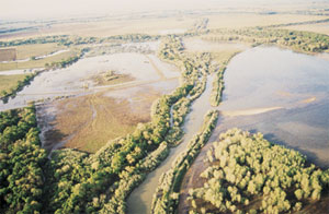
- A 1985 levee breach (center right of image) floodedlow-lying areas with nutrient-rich sediment, setting the stage forresurgent riparian woodlands later dubbed the “accidental forest.”Photo by Rich Reiner/The Nature Conservancy.
Inspiration came rather unexpectedly in 1985. A few miles east of where the visitor center now stands, a levee breach flooded fields and dumped sediment on them. Fast-growing willows and cottonwoods fanned out from the breach to establish what became known as the “accidental forest.” In 1995, biologists carved a 50-foot gap in a levee near the accidental forest. Again, the waters rushed in, and forest—this time intentional—emerged. The resulting riparian vegetation soon attracted nesting song sparrows, common yellowthroats, red-winged blackbirds, and a host of other birds.
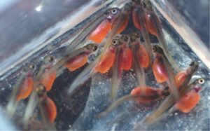
But there were some unexpected effects. Researchers at UC Davis started studying what was happening underwater in the winter-flooded forest. To everyone’s surprise, Sacramento splittail—a minnow relative that grows up to 16 inches long—were spawning on the mass of submerged stems. Meanwhile, juvenile splittail and remnants of the river’s shrinking chinook salmon population fed on millions of shrimp and other invertebrates thriving in the habitat created by the new vegetation.
Before the river was tamed, new habitat like this was created regularly by the maze of braided channels that meandered through the valley, says UC Davis geologist Jeffrey Mount. Sediment deposited by the shifting channels punctuated the broad plain with banks, bumps, and dips.
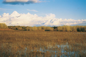
- The preserve is a mosaic of habitats, including remnantold-growth riparian oak woodlands, pioneer willow stands, and open farmfields. The “accidental forest” that sprang up after the 1985 flood hasprovided a model for later intentional levee breaches. Photo by MikeEaton/The Nature Conservancy.
Along channels, riparian vegetation would undergo a succession, with willows giving way to slower-growing valley oaks. During surging winter flow, channels would sometimes become jammed with wood, the flow would leap its banks to form a new river braid, and succession would begin anew.
The result was a “real mosaic, with extraordinary diversity, from open grassland to tall valley oak forests, and abundant freshwater marsh,” Mount says. “It was a recipe for biological richness.”
Settlement and diking for farming brought a steady reduction in complexity, a flattening of the land, and replacement of the mosaic with the repeating pattern of row crops. Today, the preserve is again becoming a mosaic, with more than a hint of its original bounty. But natural processes are only part of the story; the preserve is also managed in a way that the partners hope can benefit both wildlife and humans. The preserve includes thousands of acres of farmland, some owned by the conservancy or its partners, some held privately and protected by easements. “One of our main objectives is sustainable agriculture,” says Rick Cooper, a Bureau of Land Management employee who coordinates the work of the preserve’s partners. So the preserve is far from being a wilderness; it’s crisscrossed by roads, and freight trains rumble along raised tracks just a few yards from the visitor center.
Farming plays a big role in supporting spectacular bird populations and other wildlife. In some rice and corn fields, the stubble is cropped close to the ground after harvest; then the fields are flooded. Flooding isn’t too tough a job, since most of the preserve, though 60 miles inland, is only five feet above sea level, and the river rises and falls as much as five feet with the tide.
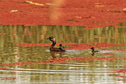
- The Cosumnes Preserve hosts about 100,000 wildfowl eachyear. Here, a pied billed grebe with its chicks paddles among floatingmosquito fern, which turns bright red in late summer and fall. Photo byTony Brake.
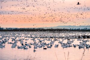
Flooded fields provide habitat for more than 100,000 wildfowl that use the preserve as a winter refuge or year-round residence, including mallards, wood ducks, northern shovelers, pintails, and tundra swans. It also benefits farmers, Cooper says, controlling weeds, helping to decompose the stubble, and adding nitrogen to the soil.
The flooded and dry fields are both vital for the cranes, which start arriving in September and stay as late as April, with peak numbers of 2,500 to 4,000 between November and February. Most of the cranes at Cosumnes are the four-foot-tall lesser sandhill cranes. A fraction are the slightly larger Canadian sandhills, and a few are the even larger greater sandhills, which are listed as threatened in California.
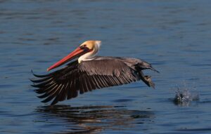
The cranes roost in the shallowly flooded areas, which harbor crustaceans and other invertebrate snacks. The open expanses of shallow water also likely allow the cranes to detect approaching predators. Each morning, the cranes fly in small groups from their roosting grounds to the drier fields where they’ll spend the day lazing, feeding—and dancing. Crane dancing can include a bizarre sequence of bows, jumps, and stick tosses. Here’s a 1999 description from volunteer preserve naturalist Mary Rodgers: “Dancing cranes bounce around like rubber balls, pirouette, hop, flap their wings, leap up to eight feet in the air.” Although often associated with courtship and mating, dancing can occur among birds of almost any age, at almost any time. Some of the best dancing takes place in January and February, and some of the best places to see the birds are near the visitor center, on Bruceville Road and Desmond Road, says preserve volunteer John Trochet. Sunset and sunrise are the best times to watch the cranes, which often become less active around midday. Trochet particularly likes to get to the preserve when the sun dips toward the horizon, silhouetting the flying sandhills as they converge on the shallow pools where they’ll spend the night. Keep a low profile, he says. “If you stay in your car and use it as a blind, cranes will land very close and dance.” When the cranes return to their roosting sites en masse in the evening, the cries of hundreds of birds are not to be missed. “Roll the window down,” he advises. Swainson’s hawks and giant garter snakes, both threatened in California, also live at the preserve and rely on its mosaic of habitats. Some of the hawks nest at the edge of old oak forests and forage in the fields nearby. The garter snakes need wetland areas to feed, but also forage in grassland and hibernate in drier elevated areas during the winter.
Currently, two trails are open to the public. The short, wheelchair-accessible wetland walk passes through former farmland now converted into tule marsh and open water, with a boardwalk and newly constructed crane viewing platform just west of the visitor center. The longer river walk takes you through fields of planted oaks, along sloughs, and out to pleasant spots beside the river itself. Both trails start near the visitor center, which also hosts nature walks and paddling tours (for folks who bring kayaks or canoes).
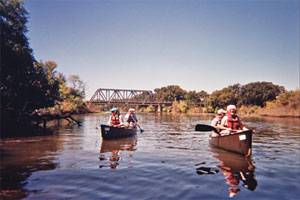
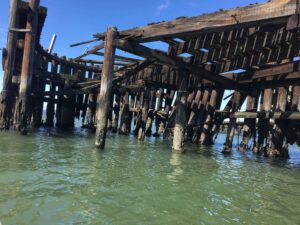
- A canoe trip gives a glimpse of the preserve’s historicabundance, but the area is far from wild. Trains rumble over thetrestle in the background, and Interstate 5 is a mile away. Photo byVicky Semones.
The expanding preserve includes other interesting areas not generally open to the public, such as the Tall Forest, an old-growth oak grove where Trochet leads monthly bird counts. Staten Island, the preserve’s most recent addition, is a few miles to the west. This Delta island, accessible by car, is a good place to see massed fowl and cranes. Howard Ranch, to the northeast, is home to vernal pools with spectacular spring wildflower displays. Preserve managers plan to open a new trail there this spring.
The preserve continues to face challenges. The biggest is encroaching development, which has driven increased groundwater pumping. Since the 1950s, pumping has sucked down the water table to as much as 80 feet below sea level. As a result, the river has dried up during summer—and remained dry long enough to prevent chinook salmon from making their fall run.
But there’s hope for the salmon. Under an agreement signed last year, canal water was released from Folsom Lake to saturate the river bed, so the river would start flowing soon after the first winter rains. That should enable salmon to reach spawning grounds in the Sierra foothills. The preserve’s partners are also buying more land, hoping to breach additional levees and free more of the river to surge across its historic floodplain. Such human intervention—informed by the previous 20 years’ experience at the preserve—may hold the key to restoring the river’s natural processes.
- Ben Pease, www.peasepress.com
Getting There
The Cosumnes River Preserve is located off I-5 between Sacramento and Stockton. Take I-580 east to I-205 to I-5 north to the Twin Cities Road exit (marked with a binoculars sign for wildlife viewing). Take Twin Cities Road east for one mile. Turn right onto Franklin Boulevard. The visitor center is located on the left side. For more information, go to www.cosumnes.org.