From the city of San Francisco, go north. Cross the rust-orange bridge above the darkly shining waters of the Golden Gate. Follow a twisting road above the shore. Walk through a concrete tunnel in the hill, past the pit dug out to house a gigantic coastal gun. Climb up a flight of wooden stairs — and there, from the top of the rise called Hawk Hill, 900 feet above the tide, what you have come to see is before you. From this vantage, the city and its structures are a texture, a stiff intricate fabric, spread over the humps and hollows across the strait.
Now turn and walk a few feet for the view to the northwest. In this direction, you find no towers, no skin of streets and buildings. Instead there is country, openness, horizon. Smooth hillsides slope down to ocean-facing bowls, rise again to higher and darker ridges. On a clear winter day you can make out forty miles of field and forest and brushland, dropping cleanly to the coves of an almost uninhabited Pacific shore.
On this hilltop, you stand on a most unusual sort of boundary. Here, without any intervening ring of suburban clutter, the central city gives way all at once to a hinterland almost wild.
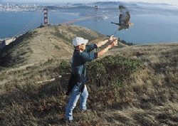
This north wall of the Golden Gate has been federal parkland for 30 years. We take it for granted that we can walk here, watch the migrating raptors for which this hill is named, look down on the towers of the Golden Gate Bridge and the great ships steaming in from Asia, revel in the flowers at our feet. Of course this place is a park. What else would it be?
But in fact its protection is the result of happy accidents and the efforts of a few persistent people. Part of the region was kept intact by the military. The other half survives because, back in the 1960s, not everyone made peace with an ambitious plan to turn the Headlands into a metropolis called Marincello.
Geologically, the Headlands are a sturdy knot of hills built largely of radiolarian cherts (sedimentary rock formed on the Pacific floor from the silica skeletons of single-celled radiolaria) and have existed for millions of years. But they owe their special character and beauty to the flooded river canyon at their feet, the Golden Gate. Ten thousand years ago, sea level was 400 feet lower, San Francisco Bay did not exist, and the Golden Gate was merely a narrow valley notched by the ancestral Sacramento River as it flowed west toward the sea. Eight thousand years ago, with glacial melting and rising sea level, a claw of salt water curved past the Headlands toward Angel Island. By four thousand years ago, the Bay as we know it had formed, with the Golden Gate its portal to the sea.
The Gate lets many things in and out. Not least of them is wind. The sea breezes and fogs it admits cool the summers over a vast stretch of northern California. Just north and south of the strait, the effect of wind is intense, drying vegetation and also misting it with salt spray. The result is a nearly treeless landscape. On ridges and seaward slopes only grasses, low shrubs, and lichen grow; small trees are confined to leeward slopes and hollows; conifers are absent. It is a scene as extreme in its fashion as the desert, with a subtle, somber, and suddenly flowering beauty.
Botanist James Roof argued in 1975 that the plant communities found in this zone qualify it as a unique floristic region, which he named the Franciscan (not to be confused with the vastly more extensive Franciscan Formation of geologists). Now, Michael Vasey of San Francisco State University is updating this idea, seeing not one but two distinct botanical landscapes at the Golden Gate, one south of the strait and one north. The northern unit consists of the Marin Headlands and perhaps Angel Island and the Tiburon Peninsula.
Both landscapes are largely cloaked in coastal scrub, also known as soft chaparral, with lots of coyote brush. Both support silver lupine (Lupinus albifrons var. collinus), summer lupine (Lupinus formosus), and the endangered butterfly that depends on these two plants, the mission blue. Many plants, though, diverge. The rare matchweed (Gutierrezia californica), named for its compact little flower heads, only lives north of the Golden Gate; the rare hummingbird sage (Salvia spathacea), to the south. The Eastwood manzanita dominates to the north; to the south, the brittle leaf. The fates of the two landscapes have diverged as well. South of the bridge, cities have all but replaced natural habitat (except on San Bruno Mountain); north, the land remains largely intact.
In 1851, three years after the Americans annexed California, President Fillmore issued an order setting aside a constellation of lands around the Golden Gate as sites for coastal defense guns. Fillmore’s boundaries included the coastal parts of the Marin Headlands, then part of a vast private rancho. When its owner demanded $200,000 — a huge price for the time — Congress fumed. “This is an enormous fraud,” said Senator David Broderick. “To pay $200,000 for 2,300 or 23,000 acres of barren land shall never receive my sanction.”
But Congress paid and the army came. Preservation was not its mission. It altered its part of the Headlands — Forts Barry, Baker, and Cronkhite — installing several generations of artillery, building dozens of buildings, and gouging miles of roads. In an attempt to camouflage its hilltop installations, the army planted Monterey pine and cypress trees and other imported vegetation. Yet between and around these intrusions, the land hardly changed.
The public, of course, was excluded, both by fences and guards and by topography. After World War II, the veil lifted a little. The army began permitting people to travel through a mile-long tunnel from Sausalito to visit the beach. A few houses were built on the heights called Wolfback Ridge, and their inhabitants liked the view. The place began to have friends. By the 1950s, coastal defense guns had become obsolete and the army was getting ready to leave. What would fill the vacuum?
The government’s first thought was simply to sell off the land piecemeal. But a handful of those new local friends succeeded in getting the forts earmarked instead for a future Marin Headlands State Park. For ten years they monitored and lobbied, wrote and pestered, and pulled strings to make sure that each parcel released by the army passed to the Department of Parks and Recreation.
But if the military half of the Headlands seemed on its way to preservation, events on the other half, the privately owned part, came close to making a mockery of that achievement. In this hinterland, in 1966, work began on a city for 18,000 inhabitants.
Marincello was the vision of a man named Thomas Frouge, a prominent developer based in Pittsburgh, Pennsylvania. Attracted to the site by its proximity to San Francisco, he seems genuinely to have fallen in love with it. “It is probably the most beautiful location in the United States for a new community,” he wrote. He secured backing from the land development division of Gulf Oil and in November 1964, announced Marincello with a massive sales campaign.
Glossy drawings and three-dimensional models showed a city unlike anything the Bay Area had ever seen. The original version of Marin-cello envisioned housing 30,000 people on the rugged 2,100-acre site. The plans called for 50 apartment towers, shoals of single-family homes, low rise apartments, and townhouses. There would be 250 acres of light industry, a mile-long central mall with pools and elephant trains, and a square bounded by churches called Brotherhood Plaza. At the summit of the city, on the highest point in the Headlands, would rise a “landmark hotel.” Construction would last 20 years and consume $285 million in 1964 dollars.
If the first thing that struck you about the project was its sheer size, the second was a certain attractiveness. Frouge marketed Marincello as a “New Town,” a dense, carefully planned, self-sufficient community in which the wasteful mistakes of conventional suburban development would be avoided. Its apartment houses would concentrate people and permit the opening of green expanses. Other urban amenities would abound. “Our goal,” said Frouge, “is to make Marincello the most beautiful planned com-munity in the world.”
Marin County leaders quickly came on board. By its very size and density, many people persuaded themselves, Marincello would relieve some of the pressure to de-velop other open land. The conservative daily newspaper, the Marin Independent Journal, supported the plan, but so did the Pacific Sun, a liberal weekly: “We expect Tom Frouge to build a city . . . which will be a showcase, which will point the way to preservation of the clear and open areas essential and unique in Marin.”
And what of the “clear and open area” that would immediately be sacrificed? The astonishing fact is that no one other than Tom Frouge yet valued it much. Not even project opponents proclaimed the subtle beauty of this windswept landscape. One of their criticisms of the plan, indeed, was that the site was unsuitable for human habitation.
Looking back on the debate, we long to put words in the opponents’ mouths. We want to hear them talk of flowers and wildlife. We want to hear them rise to the defense of Marin Headlands State Park, which Marincello would have overwhelmed. Above all we hope to hear them promote the Marincello site as a keystone in a larger coastal greenbelt. This is projection. No one had yet called attention to the possibility of such a greenbelt. If Marincello had been built, perhaps no one ever would have. “We knew we didn’t like Marincello,”’ says veteran campaigner Peter Erickson of Sausalito, “but we didn’t know what to offer as a substitute.”
On November 12, 1965, twelve months to the day after the first Frouge news conference, the Marin County Board of Supervisors approved the Marincello master plan, minus a few apartment towers. Some conservationists seemed relieved to be rid of an issue that had puzzled and divided them. But a few opponents kept fighting. They found grounds for legal action in the way the county had rushed approval and muzzled opposition, disqualifying a petition drive to bring the issue up to a countywide vote. A couple of lawsuits were filed.
Three attorneys labored on this seemingly lost cause: Robert Praetzel of San Rafael, and Martin Rosen and Douglas Ferguson of Sausalito. What drove these men at the time was not so much affection for a threatened place as fear of the precedent so massive a development would set. They were also outraged at the process, the way the county had been swept along. “I got involved not so much for an environmental purpose as a civic purpose,” says Rosen, later a founder of the Trust for Public Land. “I just felt it was terrible that these few people could turn around an entire landscape, and not even consult the local citizens. I was more Jeffersonian than Thoreauvian.”
Meanwhile, in the Headlands, construction began. At the north edge of the property, the builders laid out a wide access boulevard, climbing from Tennessee Valley into the hills. A pair of handsome stucco entry gates were built: gates leading to nothing, but not (it appeared) for long. Then, late in 1967, the noise from Tennesee Valley quieted. The work stopped. It was a crucial moment in the history of the Headlands.
It is not entirely clear what forced this pause. The menace of the lawsuits probably had something to do with it. One judge, though declining to halt the work, had warned Gulf Oil and Frouge that they proceeded at their own risk. No less significantly, Frouge and his backer had had a falling out, and were also facing off in court. A paralyzing uncertainty had set in. Even as lawyers labored, the climate of opinion was shifting steadily against the project. Slowly, imperceptibly, Marincello was becoming an anachronism.
On November 2, 1970, Gulf and Frouge settled their quarrel. On the same day, however, a state appellate court ruled on one of the long-running lawsuits against the 1965 development approval. Verdict: the plan must be submitted all over again. “To invalidate a multimillion-dollar development on a technicality is silly,” snapped a counsel for Gulf Oil. Robert Praetzel, whose legal theory was the one that prevailed, still bristles at this. “The technicality was the fact that they didn’t follow the law.”
By then an alternative to Marincello was coming into view. A government study, focused initially on Alcatraz Island, had raised the possibility of a national park around the Golden Gate. The Headlands forts, obviously, would be part of it. The Marincello site was almost immediately recognized as their necessary complement. In the ensuing two years the park concept would balloon, yielding the vast Golden Gate National Recreation Area (GGNRA) we now accept as our birthright.
Behind the scenes, Huey Johnson, then Western Regional Director of The Nature Conservancy, had begun talking to Gulf Oil, holding out an alternative to continued battle. At the end of 1972, the company sold the Marincello site for $6.5 million dollars to the Conservancy, which passed the site to the National Park Service.
Today the Marin Headlands is one of the most visited, most appreciated sections of the GGNRA, itself the most heavily visited national park in the country. Four million people, park planners estimate, head over Conzelman Road, through the Rodeo tunnel, or out Tennessee Valley every year, while the land remains prime habitat for coyotes and bobcats and, reportedly, mountain lions. Bird watchers flock to see the resident peregrine falcons and hundreds of migrating raptors. Hikers, bikers, joggers, and equestrians travel the ridges, in fog or in sunshine. Amateur botanists kneel to the flowers that, in spring, seem to cross the landscape in waves. History buffs look out from the old gun emplacements toward the horizon over which enemy fleets never came. Kids and adults at The Headlands Institute learn of the landscape and its stories. Artists of all kinds converge at the Headlands Center for the Arts. Across the way at the Marine Mammal Center, crews tend to injured seals and sea lions. Nobody seems to complain about the wind.
Few people puffing up Wolfback Ridge or meandering along the floor of what is now called Gerbode Valley (named for a Nature Conservancy donor) have any idea what was slated to be built here. But rising from the trailhead in Tennessee Valley is a curious swathe in the landscape, a gently climbing, brush-covered shelf that is far too wide for a fire road. It is all that remains of Marincello. It will be there for hundreds of years.
Support for this article was provided by the Marin Community Foundation. Learn more about them at www.marincf.org.
-300x199.jpg)
.jpg)
.jpg)