.jpg)
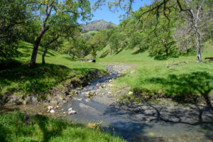
The southernmost hump of the Sears Point ridge, known locally as Cougar Mountain, looms over Highway 37. Not its height but its isolated station makes it visible from highways and byways all over the North Bay. Now its windswept slopes and the diked fields at its feet belong to the Sonoma Land Trust, forming a keystone in the emerging arch of landscape and habitat along the San Pablo shoreline.
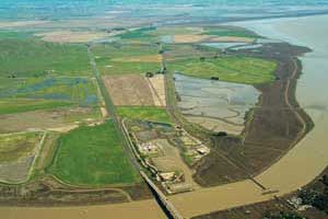
Acquired in 2005, in the aftermath of the withdrawn casino proposal, the property straddles Highway 37, encompassing both former marsh and adjoining uplands, a rare combination. It also fills in a gap between two older habitat restoration sites, the Tolay Creek inlet to the east and the Sonoma Baylands project extending west to the mouth of the Petaluma River.
Whenever scientists and stakeholders sit down to talk about restoring habitat, a debate takes place about which species to favor: marsh birds? waterfowl? shorebirds? burrowing owls? red-legged frogs? In this case, though, there was little argument. The higher ground north of the highway would be managed for upland critters. To the south, a large marsh restoration would bring tidewater wetlands up to the road and the very toe of the ridge and provide that rarest of “ecotones,” the marsh-to-hillside transition.
This is still the favored plan, but part of it is being deferred, due to the reactivation of a long-quiet freight railroad line across the site. For the time being, then, 400 acres between highway and railroad are to remain in oat hay, ponding up in winter to form seasonal wetlands, with their own considerable habitat value. The Bay Trail will run along the new bayfront dike, next to the tracks.
That still leaves some 900 acres of bay-front tideland, between railroad and bay, to be the latest laboratory of the tidal marsh restoration engineers. When the first small tracts around San Francisco Bay were reconnected to the tide in the 1970s, experts weren’t even sure that these subtle natural systems could be regenerated at all. But three decades later, much has been learned.
A key early lesson was that marshes are not gardens that need planting. If conditions are otherwise right, tidal action and seeds floating in the water or present in the soil will do the rest. A second lesson was the importance of elevation. Ideally, the ground to be flooded would be just a bit above sea level. If the base is a shade too high, marsh vegetation will form without the circulatory system of small sloughs that makes up so much of the richness of the habitat. If it is too low—the usual case, given the subsidence of most diked baylands—admitting the tide may produce persistent pools rather than marshes.

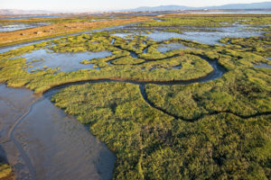
- The triangualr wetland with the curved dikes is Sonoma Baylands, with its narrow channel to the bay. The hayfields behind it will be restored to tidal influence as part of a project that includes the adjoining uplands of Sears Point (green hill in upper left). Photo by Stephen Joseph for Sonoma Land Trust, 2004.
In the early 1990s, accumulated knowledge was brought to bear on the site next to Sears Point called Sonoma Baylands. This project involved the Coastal Conservancy, which channeled funds for the land and the work, the Sonoma Land Trust, the U.S. Fish and Wildlife Service, the Army Corps of Engineers, the Port of Oakland, and sundry scientists, engineers, regulators, and back-seat drivers. Congress blessed it with money and Vice President Al Gore came out for its dedication.
At 289 acres, the restoration site was larger than any yet treated. Like the typical diked field along San Pablo Bay, it had subsided several feet below sea level. It also suffered from restricted access to open water. A narrow slough through existing marsh owned by the Fish and Wildlife Service, harboring several endangered species, could not be dredged. Given all these circumstances, researchers calculated, it might take 35 years or more for the tides to bring in enough mud to raise the bed to the level where marsh plants could root.
In this same period, the Port of Oakland was engaged in a frustrating search for an acceptable way to dispose of bottom muck dredged from shipping channels. Too much mud in one place, too little another: Couldn’t two problems find one grand solution? Between 1994 and 1996, 2.5 million cubic yards of clean mud, sand, and shell was barged 25 miles north from the port’s shipping channels, diluted into a slurry, and pumped through gigantic hoses into Sonoma Baylands, raising the soil to a calculated base level. Natural sedimentation, it was expected, would add the last few inches necessary for plants to root.
In 1996, to great fanfare, Sonoma Baylands was reconnected to the estuary. But things did not go as planned. Where the designers had hoped for incipient marsh in a very few years, they got a brackish lagoon, barely moved by the tide, that seemed in no hurry to evolve into anything else. Soon critics were diagnosing failure.
Unfair, says coastal plant ecologist Peter Baye. For one thing, he points out, the lagoon that formed was itself no mean habitat. Its floor was an underwater meadow of widgeon grass, great for diving ducks. For another, the Baylands site was indeed progressing toward the desired marsh state, if more slowly and somewhat differently than planned.
In 2004, eight years after the breach, a tipping point had arrived at Sonoma Baylands. The levee gap had finally widened as expected, the inadequate channel to the bay had scoured out, and the daily pumping of the tides had gained force. Mud deposition and channel formation were going full tilt. “It has made that threshold change,” says Baye. “You can actually see week to week the development of the dendritic channels, the capillaries winding through.”
Baye has good reason for watching this process closely, as he is involved in the design effort next door at Sears Point. Like Sonoma Baylands, this project is an attempt to profit from the experience of the past—and not least from its well-known neighbor.
A Late-Model Wetland
One lesson of Sonoma Baylands is surely patience: Success should not be expected, nor failure proclaimed, too early. But there is some genuine urgency about getting marshes established along San Pablo Bay, and the Sears Point plan aims to get there as efficiently as possible.
Sonoma Baylands started with restricted tidal access and relied on natural forces to expand it. At Sears Point, no chances are being taken. The four or five dike breaches will be generous, and the plan calls for channel dredging outside the openings as needed to make sure that enough water volume moves in from the start.
Projects of Sonoma Baylands’ vintage treated the basin bottom as a raw material to be carved by the tides. But sometimes the ground refuses to be carved. The Sears Point team plans to sample soil conditions carefully, break up barriers where necessary, and lay out some seven miles of starter channels along the old slough systems.
Sonoma Baylands imported sediment; this is being replicated at another Coastal Conservancy-funded project, Hamilton Field in Novato, but not at Sears Point next door. Yet even here the new project profits from the old. Where the Port of Oakland slurry came gushing out of the pipes, it tended to form piles, producing a series of low, shallowly sloped hillocks. Accidental though they were, these mounds proved to be important starter sites for marsh vegetation. The Sears Point terrain is to be studded with similar hillocks and other soft, deceptively random features.
Sonoma Baylands went in one fell breach of a dike from a dusty construction site to an arm of the bay. At Sears Point, the plan is to go fast by going slow. According to John Brosnan, project manager for the land trust, after water is first admitted, it will be partially drained and then kept at low levels, a managed wetland, not a tidal one. The shores will quickly green up with cordgrass and bulrush, and the pools will draw shorebirds and dabbling ducks (another Baylands lesson being to appreciate “interim” habitat). Only after a couple of years will the dike be opened for good. Most of the first plants will drown, but their dead stalks and roots will trap mud and reinforce the carefully sculpted landforms.
Room to Connect
Sears Point has something going for it that most previous projects did not and could not have: a wetland neighborhood. To the west, the planners hope, it will link to Sonoma Baylands through an additional dike breach (to the benefit of both projects). To the east, three more breaches will connect it to the Tolay Creek inlet, where a planned marsh restoration has been impeded by limited tidal exchange. With the old barriers perforated, the three wetlands can merge into a more generous tidal expanse extending west to the mouth of the Petaluma River and beyond: a whole much greater than the sum of its parts and just the sort of linkage still possible in the North Bay.
Connections of other sorts are being made at Sears Point. This is the stretch along Highway 37 best suited to being a public portal into the expanding world of the marshes. And it is the place where the citizens groups and agencies behind North Bay restoration most visibly connect. Four different public and semipublic agencies own land here, and at least four more regulatory bodies must sign off on every decision. It’s an environment of enforced cooperation, where owners, advocates, and agencies come together to shape a greener, wetter future.
The San Pablo National Wildlife Refuge, long in search of a permanent headquarters, has found one here in an old farmhouse lovingly restored with volunteer labor. On a gentle hillside just south of the highway, it awaits only easier access to become an important public contact point. Nearby is the refuge’s native plant greenhouse, a focal point for volunteers from some of the citizen groups that have provided the impetus over the years for North Bay restoration: Friends of San Pablo Bay National Wildlife Refuge, Save the Bay, the Bay Institute, and several Audubon societies.
At the foot of the same hill is the future route of the Bay Trail. Five miles of this 400-mile regional pathway will wander along the new shoreline from the Petaluma River to Tolay Creek, perhaps traversing the Paradise Winery, which occupies the very tip of the Sears Point Ridge.
“Sears Point,” says Beth Huning of the San Francisco Bay Joint Venture, “is one of those properties that put it all together.” Looking both at Sears Point and the wider world of the San Pablo Baylands, Nadine Hitchcock of the Coastal Conservancy sees a large return for the public and private monies that have been invested in preservation and restoration here. “Where else is there potential like this?” she asks. “It’s a renaissance.”