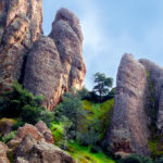
Volcanic drama, bat caves, diverse wildlife, roadless vistas: Pinnacles National Monument is definitely worth the trip.
Sign up for our free weekly newsletter and understand everything better!
Volcanic drama, bat caves, diverse wildlife, roadless vistas: Pinnacles National Monument is definitely worth the trip.
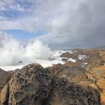
You’ll find some of Central California’s most remarkable rocks at this state park on the Sonoma coast. Waves, fault lines, and changes in sea level have left sublime stories written into the landscape.
-150x150.jpg)
There’s no mistaking the signs of this year’s late spring in the Presidio, with California poppies, beach strawberries, and beautiful (but invasive) calla lilies appearing in increasing numbers every day. But the Presidio is also experiencing a far more gradual and deliberate regrowth as well: that of its network of trails.
-150x150.jpg)
On Mother’s Day you call your mother. On Father’s Day you thank your dad for his guidance and support. On National Trails Day you…pick up a shovel?
-150x150.jpg)
From the top of Dillon Point in Benicia State Recreation Area, you can trace the route of the Carquinez Strait Scenic Loop Trail, a 50-mile route that will, when finished, ring the strait.
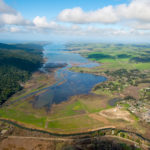
Wildlife thrives at Giacomini Wetland at the south end of Tomales Bay.
-150x150.jpg)
Stevens Creek is a 20-mile stream that originates on Black Mountain at the crest of the Santa Cruz Mountains before cutting through the heart of Silicon Valley and out into San Francisco Bay. Eventually, the Stevens Creek Trail will run the entire length of the stream. But you can check it out now…
-150x150.jpg)
Make getting there part of the adventure with our update of the region’s transit-accessible trails. From backpacking on Mount Diablo to strolling the Bay shore in Mountain View, there are many ways to get outdoors without adding to your carbon footprint.
-150x150.jpg)
It has been over a year now since I took the plunge into car-free existence. The one-way, overnight backpack trip up and over Mount Diablo that I took last fall is one example of the kind of adventure I have been enjoying since I said good-bye to my car.
.jpg)
Download our updated map showing transit connections to protected parks and open spaces all over the San Francisco Bay Area.