In 2014, the San Francisco Bay Trail marked its 25th anniversary by dedicating the trail’s newest segment, 2.7 miles at Hamilton Wetlands. The Bay Trail Plan was adopted by the Association of Bay Area Governments in 1989 to provide public appreciation of the region’s signature natural asset. For a listing of upcoming 25th anniversary events, go to baytrail.org/events
imagine many of you are like me: you jog a little but wish you biked more? You know there are new trails along the Bay shore but you always go to the same one? You’re feeling a little older or wimpier so you opt for yoga or the warm pool over strenuous outdoor activity? After all, it could get foggy, there could be traffic … It’s hard to believe a friend once called me “intrepid.”
I admit that on the warm clear morning when I get my not-so-intrepid rear end in gear for a bike ride, I have help. My husband has been trying to lead by example for several years now. He bikes from our San Francisco home across the Golden Gate to Tiburon and back; he jogs long enough to come back tired enough to fall asleep right after dinner. That morning I wheedle him into strong-arming the oily bulk of my bike into the backseat of our compact while I make a show of carrying the front wheel. He manages a grunt of encouragement and strides off to work shaking his head.
The hard part done, I feel pumped up as I head north to explore the newest miles of the San Francisco Bay Trail, which is celebrating its 25th anniversary this year. I look forward to revisiting the former Hamilton Army Airfield near Novato, a landscape I’d last seen covered with mud and construction crews, and to free-wheeling along new marshes designed by humans to help endangered birds and mice. I have no clue I’ll also get into a spot of bother.
The first thing that hits me as the tread of my bike wheel grabs the grit of the new trail—a sandy facsimile of the yellow brick road—is the smell of the sea. I’d assembled the bike, stymied briefly by how to reconnect the brake wire, in the suburban parking lot at the south end of Hangar Drive. The lot, opposite a walled community, offers access to ball fields, a kiddie park, and the Bay Trail. That morning it was full of mothers calming toddlers who needed naps.
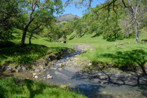
Coming out of that hot, close pocket of family life up onto the levee and seeing and smelling the Bay spread out before me is both a relief and a surprise. There’s nothing new about the environs—many segments of the Bay Trail originate in shoreline office parks and lagoon developments. There’s often a wall, with trail and Bay on one side and three-bedroom homes on the other. But the baylands vista feels different here than it does in the South Bay, which is less rural and still dominated by the architecture of salt making. Here on the east shore of San Pablo Bay, I note more trees and more hills. I smile and follow the breeze.
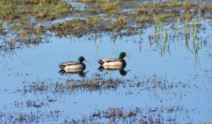
Hamilton’s newest stretch of Bay Trail shadows a slope of black oak forest and winds along wetlands to a point that promises a view. On my way there, I spot four pairs of mated mallards, each claiming their own finger of water. In every pair, one has its head down, dabbling for food, while the other remains on lookout. A non-birder, I feel proud to have noticed.
A short pedal brings me to the lookout point, where the varnish on the new fencing is still recent enough to smell. Tall towers poke through a hint of fog on the horizon—you might think it’s the San Francisco skyline but the lay of the land is confusing. From here, Point San Pedro (on the Marin side) and Point San Pablo (the Contra Costa promontory) merge, hiding the Bay proper. It took an earlier walk on this same stretch with Bay Trail planner Maureen Gaffney to reveal the true identity of the city in the mists: Richmond’s Chevron refinery.
A man in shorts walks up and, just as I had done, inspects two panels placed prominently in front of the view over Hamilton’s future wetlands mosaic. There’s nothing posted on the panels yet. I ask him what he knows about the landscape, which turns out to be a lot. Ralph Reyes has lived at Hamilton for 10 years and has done his homework on the activities offshore. He even knows dredged material was used to raise the subsided farm fields and airfield back up to elevations more hospitable to wetland plants. “This is awesome; nature’s clawing its way back onto this land, and the birds are amazing,” he says.
After putting up with dust, noise, and construction for years, locals like Ralph are making the most of their new access to the shoreline, including for midday breaks. Reyes tells me he walks here every day. “This wetland and these trails are a huge benefit to our community, increasing housing values, making it a more desirable place to live,” he says. “It’s awesome, but what happens when the tide turns, when someone decides it’s so attractive we need another mall?”
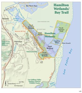
A clean rope and a polite sign block me from continuing south. Planners hope to close the 700-foot gap between the sign and the next three miles of Bay Trail eventually, but first they have to find a way to work around some endangered California clapper rail habitat. Once that has happened, I’ll be able to pedal all the way to the Marin Civic Center from Hamilton. In the meantime, from this distant vantage point, Frank Lloyd Wright’s county seat looks like a spaceship crash-landed in the forest.
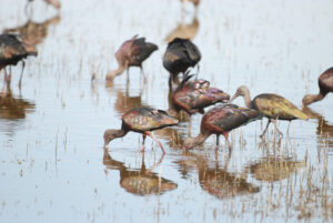
Heading back and along waterfront homes, I pass two cormorants fishing in a storm water outflow channel. The bulky white bird in flight must be a great egret, I think—the head is too elegant for the white pelicans drifting in distant waters like buoys. A good mile or more away out on the Bay horizon trucks and a backhoe are taking the levee that separates the Bay from the former airfield down a notch. In addition to a big breach in the levee on April 25, the final stages of this elaborate restoration project have involved scraping off the top three feet of dirt so a high tide can overtop it, adding the final ingredient to the mix of habitat types prepped by the U.S. Army Corps of Engineers and the California Coastal Conservancy: water.
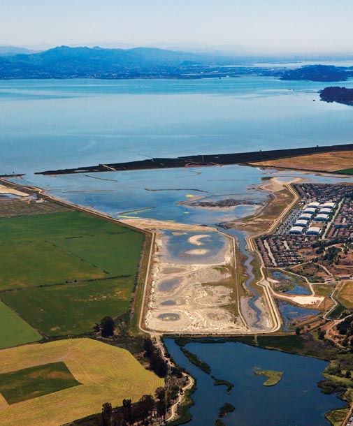
Looking out across the 650-acre project toward the distant Godzilla arm of the backhoe against the blue sky, I finally see on the ground what the planners and engineers have been describing to me ever since I first began writing stories about Hamilton ten years ago: a tapestry of habitats. The lay of the land is bumpy—watery here, carpeted with yellow brass buttons there, clumps of green, hummocks of earth, pools in shades of gray. Everywhere there are signs of good intentions: blue and white flags marking the planting sites of sapling willows; ridges in the dirt left behind by earthmoving equipment; holes in the ground waiting to be filled by bench legs.
“Seeing the final construction crew at work with the dump trucks and excavator is exciting,” says Amy Hutzel of the conservancy, one of several people with a role in the project whom I had met at this same vista point days before. “What’s most unbelievable to me, though, is that all this fill was dredged out of the bottom of the Oakland harbor and brought all the way here. It took quite a lot of work to raise the elevation and get it all sculpted so the site can evolve on its own.”
The Army Corps did the heavy lifting and built the backbone of the new Bay Trail. But it’s the tapestry I marvel at when I consider all the progress, and so does Hutzel’s conservancy colleague Tom Gandesbery, who has worked on the project for more than five years: “When we laid the whole thing out, it was just solid, desiccated mudflat, not much to look it. Then after they graded it and planted it, we got some topography and some greenery. The water catches my eye now, in the different ponds.”
While we’re chatting, two white-haired women set out on a walk they take several times a week. “At first there wasn’t much water or many birds. The water adds another dimension, and so do all the yellow flowers showing up. We can see everything unfolding,” says one.
“I’ve lived around here for 40 years, and my husband’s father was stationed here,” says the other. “Now, we’re seeing jackrabbits, geese, ducks, and hawks.”
Back on my bike ride, I pass Hamilton’s former airplane hangars and northern cul-de-sacs and arrive at a fork in the trail. Left leads down to a native plant nursery created to supply this restoration site; right, which I choose, leads toward the community of Bel Marin Keys across farm fields owned by the state, where neighboring wetlands are planned. Red-winged blackbirds hop out of the way by the dozen as I bike, enjoying the freshwater seepage. It’s not as wild on this stretch of trail—Bel Marin’s blue-and-white-painted homes stand out more in the distance than the earth tones no doubt mandated by the Hamilton homeowner associations. The wind carries the whip of highway traffic to my ears. Lone men jog past, adding the steady crunch of gravel to the local sound effects.
Out near Pacheco Pond, as I hop off the bike for a water break, a slim striped snake slides between my Nike-padded feet, curls for a hiss, then disappears under an orange construction cone. I blink, decide it wasn’t a rattler; more likely a common garter variety reptile. Probably a California red-sided garter, but certainly “wildlife”— a good sign for a construction site.
I must look like I’ve seen a ghost, because a truck pulls up and the driver asks if I’m okay. I recognize Eric Polson, one of the engineers behind Hamilton’s face-lift. I ask Polson how it feels, having worked on the project more than 18 years, to be going into the final breach. “I’m glad we’ve come this far … we’ve even seen a family of otters exploring our new ponds … but I’d like to see the Bel Marin parcel finished too,” he says.
I hadn’t planned to continue up the narrower levee-top trail along Pacheco Pond, but the conservancy’s native plant crews have thinned the thickets of eucalyptus on either side, opening up the views. I wobble a bit, timid on the rougher terrain, and stop to admire the waterfowl, only to be attacked by an unidentified buzzing object. I bat at the insect—big enough to make me think horsefly or monster wasp—which dive-bombs my head. I pull off my cap and swipe at it, but before I can get away, it’s in my hair, stinging my scalp. Somehow I get on my bike and head for the hills, finally losing the buzzer (but carrying the stinger all the way back home to my husband and a pair of tweezers).
Between the snake and the UFO, I’m now a little spooked but soon settle into the ride home, putting my back into it. I manage a good three-mile sprint—enough to remind me how much I enjoy biking and how little it aggravates my grumpy knees and bad back. Parking the car back in the city, I decide not to take the bike out of the car. Maybe I’ll go for another ride tomorrow.
After a shower and a Benadryl for my swelling head, I sift through the Bay Trail map card set Maureen Gaffney had given me to plan my next ride. She clearly enjoys the variety of Bay Trail bits she is working to connect, from the crowded sidewalks along San Francisco’s Embarcadero to a remote corner of the San Pablo Bay National Wildlife Refuge where hares and hawks are more common than humans. “Now that we’re 25 years in, it’s easier to keep going because all the jurisdictions—the cities, the counties, the communities—accept that we should do this 500-mile trail around the Bay,” she says. “But it’s also harder because now we’re planning trail for the more challenging segments like Highway 37 and the west span of the Bay Bridge. Those are years away.”
Time enough for me to get in shape.
—
GETTING THERE:
From Main Gate Road in Novato, there are three trailhead options:
1. Reservoir Hill: From Main Gate Road, take a left at the fork in the road and head up the hill on North Hamilton Parkway. Trailhead is on the right. (limited parking)
2. Hangar Parking Lot: A ramp opposite the old Control Tower goes over the City’s levee and connects to the trail.
3. Palmisano Park: Parking at end of Hanger Avenue, by service road that connects directly to trail.
Dogs must be on leash. No public restrooms on site.
More information at http://hamiltonwetlands.scc.ca.gov/public-access/.
Ariel Rubissow Okamoto, editor of Estuary News, the quarterly newsletter of the San Francisco Estuary Partnership, is also a co-author of The Natural History of San Francisco Bay (UC Press, 2011) and writer of numerous articles on Bay Area watersheds.


