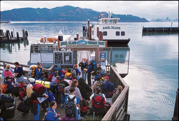
On an August morning I boarded Tiburon’s Angel Island ferry behind about 50 kids running down the metal plank, slamming into the day. As they reached the open-air deck at the top of the boat, one boy asked another, “Do you know there’s a shark out there with a mouth as big as a car?” His friend had no time to respond—from the other side of the boat, someone yelled, “Sea lion!” and off they ran.
As the ferry crossed the choppy waters of Raccoon Strait, a dozen brown pelicans flew high overhead. Blue skies dominated, but a tenacious fog spread like a quilt over San Francisco, and a small patch of it sat on top of Mount Livermore, the highest point on Angel Island and my destination that day.
Angel Island State Park is often referred to as the jewel of the Bay, and like a jewel, it shines differently depending on which facet you are viewing. At roughly a square mile, it is the largest of the Bay’s 48 islands and thus has the greatest diversity of natural habitats. From the open Bay to the shallows and beaches along the shore to the oak woodlands and chaparral highlands, Angel Island is large and diverse enough to have its own peculiar natural history, a bit of island ecology in sight of our urban edges. With its shards and relics of wars and immigration history, it’s also a keeper of cultural memories. Acre for acre, it is one of the richest landscapes in the Bay Area.
Summertime is high season at Angel Island, but many visitors don’t go beyond the lawn or picnic areas in Ayala Cove, so it doesn’t take long to get away from the hubbub of school groups or the Disney-like tramcar that takes visitors around the island on the Perimeter Road. A great way to explore the tranquil core of the island is to hike the trails on the ridge that crowns Ayala Cove. The Sunset Trail follows the southwest spur of the ridge leading to Mount Livermore, and the North Ridge Trail hugs the northwest spur.
- The Tiburon ferry, which sails four times a day in summer, is the last family-owned ferry company on San Francisco Bay. Photo by Wyn Hoag.
I picked up the Sunset Trail at the Perimeter Road and started the gentle climb up the southwest spur through a shady forest of coast live oak, bay laurel, hazelnut, and toyon. In spring the trail’s edges are green and lush with Indian (miner’s) lettuce, bedstraw, stained-glass mission bells, and unfurling maidenhair and bracken ferns. Mature poison oak bushes grow like a ceiling over parts of the trail and climb in thick vines, so watch out for them.
After about a half mile, the trail opens to the first overlook, with a view of the Golden Gate Bridge. Depending on the tides, you may notice the frothy sinuous edge of a flood tide rushing through the strait toward the Delta. On a January visit, I counted waves of double-crested cormorants flying inland like piercing black arrows. There were at least 40 birds in each wave, and they kept coming until my count reached 300 birds. While hiking the island, you may see crows, turkey vultures, red-tailed hawks, juncos, white-crowned sparrows, and scrub jays, but turn around and you’ll also see California gulls, brown pelicans, cormorants, and western grebes to remind you that you are in the middle of the Bay.
At 140 feet deep, Raccoon Strait is one of the deepest parts of the Bay. By 400,000 years ago, the Sacramento and San Joaquin rivers had met and broken through the Coast Range. In charting its new course to the Pacific, the river scoured through Carquinez Strait and the Tiburon Peninsula. Why the waters cut through the ridge that connected Angel Island with Tiburon rather than flowing to the east, geologists don’t know for sure. But UC Berkeley professor Doris Sloan suggests that the ancient landscape would have looked much different than it does today, with long-gone faults and uplifts affecting the river’s course.
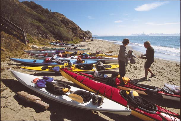
- Angel Island is a popular destination for kayakers, like these at Perles Beach on the island’s southwest side. Photo by Wyn Hoag.
The scouring of the peninsula was the first step in the making of an island, says Sloan. As ice caps melted, rising sea levels filled the Bay. By about 6,000 years ago, many of the animals that lived on the island were trapped. Some of those species have died off, but the broad-footed mole survived and evolved into a distinct subspecies, the Angel Island mole. Raccoons, mule deer, lizards, salamanders, and snakes live on the island, including the rubber boa snake, which is not known to live on any other island in California.
Like most of the oldest rocks east of the San Andreas Fault, says Sloan, the rocks that make up Angel Island belong to the Franciscan Complex. While Angel Island and the Tiburon Peninsula have rocks in common—sandstone and shale, blue and green schist, and serpentinite— there are differences. For example, basalt constitutes nearly half of Angel Island, but is absent across the way at Ring Mountain on the Tiburon Peninsula.
While there are better-known exposures of pillow basalt (a submarine volcanic rock that formed new ocean crust deep underwater as two plates separated), you can see it near Camp Reynolds. South of the seawall beyond the brick building, the first exposure of rock you come to is pillow basalt with thin veins of blue schist.
At the Sunset Trail’s second overlook, I looked downhill for Camp Reynolds and Point Stuart, but they were hidden from view. Long before these sites were given their modern names, the Hoo-kooeko band of the Coast Miwok paddled across Raccoon Strait to hunt and fish on Angel Island. Middens and artifacts show that humans have been visiting the island for at least 3,000 years. In 1775, when Don Juan Manuel de Ayala moored the San Carlosin the sheltered western cove that would bear his name, he christened the island Isla de Nuestra Señora de Los Angeles after a religious feast day. Ayala’s chaplain kept a journal of their encounters with the Miwoks and described them as having an “elegance of figure and quite faultless countenance.”
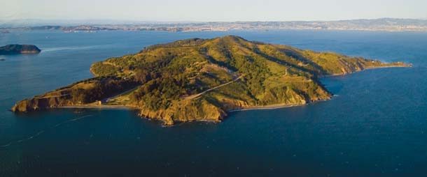
- Angel Island from the southwest. Camp Reynolds is the beach on the lower left. Photo by Kira Stoll.
Later, other explorers stopped at the island to stock up on wood and water. In his travel narrative Two Years Before the Mast, Richard Henry Dana Jr. wrote of gathering wood here in 1835: The island “was covered with trees to the water’s edge; and to this two of our crew, who were Kennebec men and could handle an axe like a plaything, were sent every morning to cut wood, with two boys to pile it for them. In about a week, they had cut enough to last us a year.”
By the time Camp Reynolds was established as a defensive battery during the Civil War, much of the coast live oak, madrone, and bay laurel that came “to the water’s edge” were gone. Photographs taken then depict a nearly denuded landscape.
In the early part of the 20th century, the army began an aggressive tree-planting program with nonnative trees, predominantly Tasmanian blue gum eucalyptus. The 24 acres of trees they planted in small groves proliferated until the island was littered with them. Eucalyptus must have seemed a perfect solution at the time. They grow fast and tall, are pest resistant and, when full grown, are elegant and haunting giants. Through the years, however, they have taken over habitats, forcing out native vegetation. They are also a fire hazard, a serious problem on an island with limited emergency services and water supplies.
When state park workers began to remove eucalyptus in the 1990s, the trees covered 86 of the island’s 740 acres. “That’s a lot for a small island,” says David Boyd, recently retired California State Parks Marin District senior environmental scientist. “They dominated the landscape.”
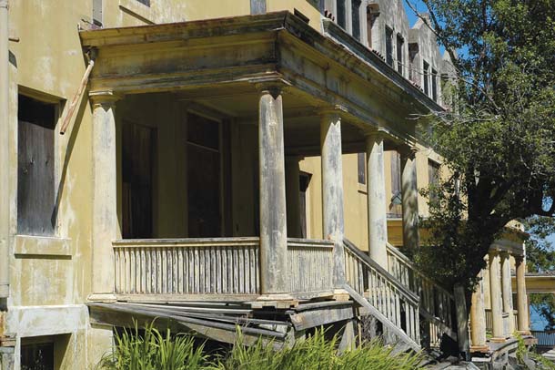
- Much of East Garrison (also Fort McDowell) is today in ruins, but it saw service during the Spanish-American War and both world wars. Photo by Francis da Silva.
By 1996, Boyd and his crew had removed 80 acres of eucalyptus. Above Perles Beach, the trees were replaced with California sage and coyote bush. Native purple needlegrass—our state grass— has returned to the area. Unfortunately, Italian thistle also managed to muscle its way onto the island. Boyd, who snarls at the sight of it, says, “If it was just in patches we’d ignore it, but it’s everywhere.” Herbicides didn’t work, and a controlled burn was a “total failure that produced a lot of smoke.” Now crews mow the thistle annually before it goes to seed.
Not all nonnative plants are removed. Part of the park’s mission is to preserve historic resources, and Ayala Cove, Camp Reynolds, Fort McDowell, and the Immigration Station are managed with an eye toward preserving plants with cultural significance, such as the purple-flowered Pride of Madeira and even some remaining eucalyptus. On the rest of the island, park managers preserve and restore native resources. While the mission is clear, implementation has become more difficult due to limited funds, as at all state parks.
Coming out of the woods again, I saw Alcatraz Island and the Bay Bridge for the first time. On the island’s south side, the wind is strong enough to blow my hat off and stunt the poison oak bushes that grow in the open chaparral along with coyote bush, California sage, and manzanita, all well adapted to the harsh southern exposure.
As the trail turns north along the east side of the island, a few tenacious California poppies accent the edge where it looks down on East Garrison (also called Fort McDowell). East Garrison held prisoners during the Spanish-American War, served as a discharge and recruitment center during World War I, and housed soldiers waiting for embarkation during World War II. Today, several of its cement structures are open to wind, weather, and curious explorers.
“The island isn’t angelic,” says Alan Miller, a retired UC Berkeley professor who brought his environmental studies students to Angel Island and now leads public tours. “It’s a microcosm of the political, economic, and social situation in the United States. Fort McDowell alone saw 100,000 people come and go between the Spanish-American War and World War II.”
Several years ago, before the Immigration Station was closed for renovation (it’s currently scheduled to reopen in February 2009), I came upon a sign made of eucalyptus leaves on the road. In foot-high letters, it read: “Danger sadness ahead.” Around the corner lay the Immigration Station, a processing and detention center for immigrants who arrived by sea, including 175,000 Chinese who hit the wall of the Chinese Exclusion Act, passed in 1882 and in effect for decades. Detained like criminals for as long as several months, many of the men carved their stories into the barrack walls. Their poems told of their ocean crossing, their homeland, their humiliation, and the uncertainty of their lives. They didn’t write about the island’s natural beauty because they weren’t allowed to see anything beyond the barred windows and the fenced exercise yard.
In 1954, the same year that 36 acres at Ayala Cove were turned over to California State Parks, the army installed three Nike missile sites on the southeast corner of the island and removed 18 feet from its summit to make way for a radar station and helicopter pad. But within eight years, advances in missile technology made the never-fired missiles obsolete, so they were booted off the island, bringing an end to the island’s military career. Except for Point Blunt, which is used by the Coast Guard, the rest of the island had become a state park by 1963, flattop and all.
After removing all those eucalyptus trees, Boyd thought the next logical step in the island’s restoration would be to put its top back on. So beginning in 2002, crews removed the paved road, bulldozed the dirt that had been pushed over the sides back on top, built a new walking trail up to the summit, and replanted the bare soil. Mount Livermore, with its 360-degree views, can once again lay claim to being 788 feet above sea level, a measurement that will likely change again as global warming and resulting rises in sea level alter the natural and cultural facets of this San Francisco Bay jewel.
Getting There
Check ferry websites for schedules, which change seasonally. From Marin, take Tiburon Boulevard off us 101 to downtown Tiburon. The Angel Island-Tiburon Ferry (www.angelislandferry.com) is located at 21 Main Street. From San Francisco, catch the ferry at Pier 39 (www.blueandgoldfleet.com). In the East Bay (weekends and holidays, May through October), the Alameda/Oakland Ferry leaves from 2990 Main Street, Alameda, and Oakland’s Jack London Square (www.eastbayferry.com). Also, during the summer, Alcatraz Cruises out of Pier 33 runs an Angel Island/Alcatraz combined tour; for details, go to alcatrazcruises.com.

.jpg)
