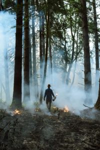
As the North Bay fires are increasingly contained and communities begin to rebuild their lives, a picture is emerging of where the fires burned. It’s a patchwork landscape of homes, farms, and undeveloped lands containing various habitats, including chaparral, grasslands, mixed woodlands, and streams.
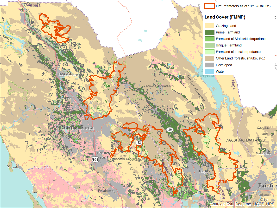
Data released by the Bay Area Open Space Council this week detail the acreage of land burned in Sonoma, Napa, and Solano counties and its various uses. According to the data, the fires passed over 75,000-acres of farmland in the two counties, with almost 4,000 of those acres supporting important agricultural crops, such as orchards and vineyards.
The combined fire perimeters encompassed 64,000-acres of land suitable for grazing, and more than 70,000 acres of largely undeveloped, non-agricultural land, including parks, preserves, and private properties that supported shrubs, woodlands, wetlands, streams, and some rural operations.
Perhaps most critical are the 3,700-acres of developed land directly affected by the fires. Though the acreage is a fraction of the other burned landscapes, it encompasses neighborhoods and commercial areas and represents some of the most devastating human losses.
“Therein lies the reason why this fire is a chart-topper in terms of devastation,” says Tom Robinson, director of conservation, science and innovation for the Open Space Council.
Parks and other undeveloped lands may not, in some cases, have fared badly in the fire, even when they fell largely within the fire zone, Robinson and others are saying.
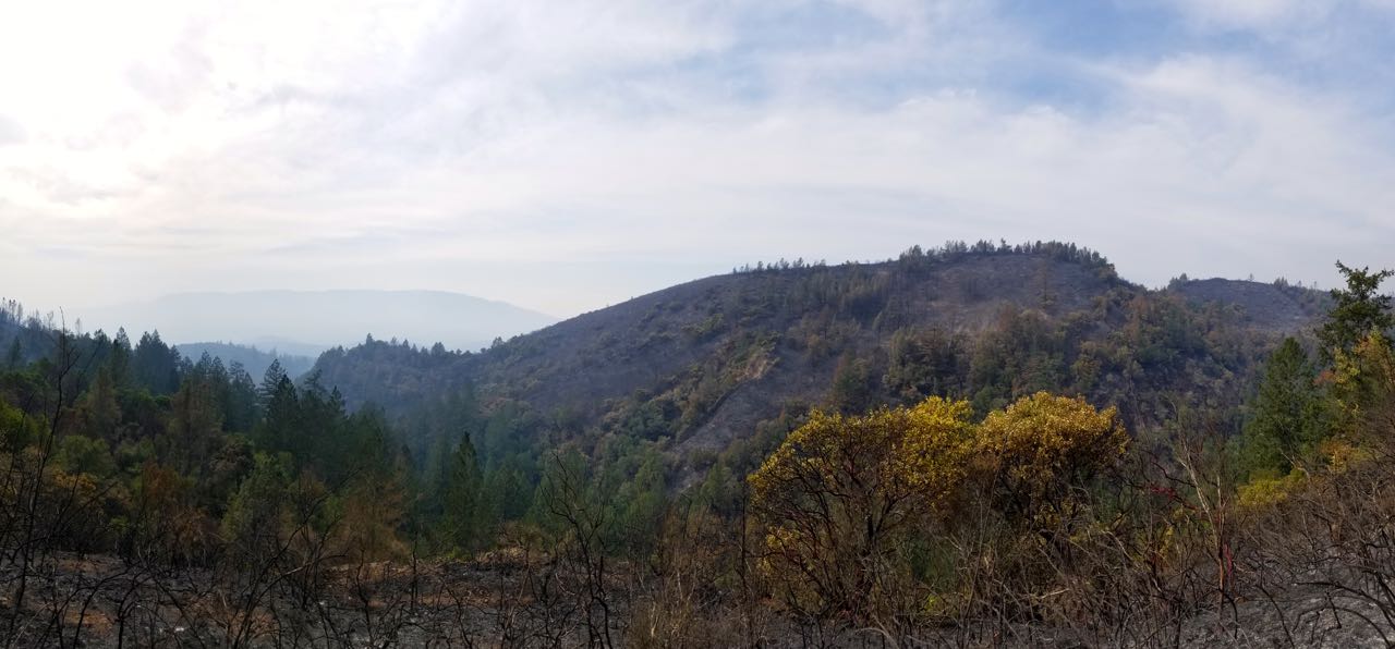
Approximately 61 percent, or 3,107-acres, of Trione-Annadel State Park on the outskirts of Santa Rosa was within the fire perimeter, making it the park most affected, by acreage, in the two counties. Yet, the park is still green in places.
“Just looking at the fire from my rooftop, I can see much of Annadel State Park,” says Robinson. “You can see areas that burned really intensely and other areas almost look like a controlled burn —the trees are still standing and have green leaves. It will take some time to determine whether those trees got too hot and will eventually die.”
Some of the other parks and preserves consumed by the fire include Pepperwood Ranch Natural Preserve, north of Sonoma; 2,783 of its acres were in the fire zone, or 91 percent of its lands. Further south some 1,522 acres, or 43 percent, of Sugarloaf Ridge State Park burned, while 100 percent of the smaller, restricted-access sites at Bouverie Preserve near Glen Ellen, and Foote Botanical Preserve, east of Napa, fell within the fire’s perimeter.
Sasha Berleman, a fire ecologist for Audubon Canyon Ranch, which manages Bouverie Preserve, says she’s been out on the 535-acre property and also got a look at Sonoma Valley from Highway 12 by Hood Mountain to Sonoma Valley Regional Park.
“When I looked at the entire side of the valley that was in the burn area, it’s really clear that although the fires were absolutely tragic in developed areas, the effects on the landscape were overall what you would want to see a fire do,” she says.
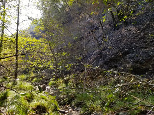
Berleman explains that the Sonoma and Napa plant communities are well adapted to fire, and the health of their ecosystems even requires occasional burns. She says from what she saw, the chaparral lands along hot, dry south-facing slopes burned severely, as they should. Cooler, moister areas that encompass woodlands were in some cases so minimally burned they look almost untouched, she says.
“It was a patchwork of severity across the hillside. It was not all just black,” she says. “It’s good news, it looks like, based on my initial assessment of this one area. At least at first glance, the forest is going to be okay and the chaparral is going to come back.”
The fire may prove ecologically beneficial in a number of ways. Land managers in the two counties and elsewhere in Northern California have been nervous about the dangerous levels of vegetative growth on the landscape for some time, and Berleman has led a multi-agency effort to coordinate highly controlled “prescribed” burns on open space lands.
Prior to this fire, one section of Bouverie preserve had a vast 35-acre section of knobcone pine. “I went walking through the knobcone pine, and I’d sink one foot deep in pine needles and chaparral leaves. It was a total mess up there,” she says. “We had these huge fuel loads, and we couldn’t figure out what to do with them. Now that they’ve been cleared out, it gives us a chance to maintain them from square one, moving forward.”
The initial assessment at Pepperwood Preserve is similar.
“…Many oaks are still standing and it may be a fraction are just fine, but it is very hard for us to tell at this point,” according to a message posted on the research station’s website. “In many places the understory has been cleared by fire but larger trees are still standing so we will need to monitor tree mortality moving forward. We do see some big standing Douglas fir trees that look dead …”
Already, Berleman and Pepperwood officials intend for the events to galvanize new efforts to study and manage the landscape for fire. In the meantime, visitors to these parks will get a new experience — likely a bountiful wildflower season in the spring, a healthy acorn crop unharmed by weevils, and where knobcone pines once stood, hundreds of seedlings poking through the charred earth.