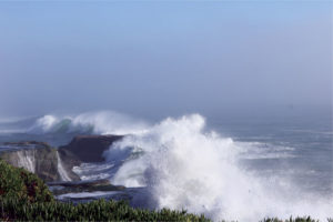
A strong El Niño’s headed our way and its effects on California this winter could be significant, with heavy rains, abundant Sierra snow, devastating flooding, and destructive coastal erosion. Or maybe not.
Remember, they are an exotic species in the Western United States, and are rapidly increasing their geographic range and range of habitats. Are they outcompeting or excluding native species in the process? How would we know? We have done almost nothing to monitor changes in the assemblage of mushroom species in areas before and and after the incursion of death caps.
Further Reading
Pringle et al, “The ectomycorrhizal fungus Amanita phalloides was introduced and is expanding its range on the west coast of North America,” Molecular Biology 2009
Lockhart et al, “Simultaneous emergence of multidrug-resistant Candida auris on 3 continents confirmed by whole-genome sequencing and epidemiological analyses,” Clinical Infectious Diseases 2017
Battalani et al, “Aflatoxin B1 contamination in maize in Europe increases due to climate change,” Scientific Reports 2016
El Niño: Beyond the Hype

Bay Nature goes beyond the headlines to explore what the strongest El Niño in recorded history might mean — or not — for Northern California. Starting next week, we’ll post new articles here every Tuesday through the fall.
This series has been funded by donations from Bay Nature readers. Please help us by sharing our work, or donate today to support our mission to explore the natural world of the Bay Area.
Either way, wet or dry, the 2015-2016 winter season will go down in the record books. If wet, this year’s ENSO (the science acronym for El Niño Southern Oscillation) could replicate what happened decades ago during two other strong El Niños when rainfall records were set; if dry, because the forecast ENSO fizzles, well, that too will be record-setting but in very different ways.
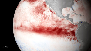
Right now, all meteorological and oceanographic organizations agree the global stage is set for a strong—perhaps even a very strong—El Niño episode over the next six months. While El Niños of the weak or moderate category happen fairly regularly, coming and going with largely insignificant effects on central California, we’ve had two ENSOs in the last half century of the strong category: the winters of 1982-83 and 1997-98. And both were notable in the Bay Area.
Remember, they are an exotic species in the Western United States, and are rapidly increasing their geographic range and range of habitats. Are they outcompeting or excluding native species in the process? How would we know? We have done almost nothing to monitor changes in the assemblage of mushroom species in areas before and and after the incursion of death caps.
Further Reading
Pringle et al, “The ectomycorrhizal fungus Amanita phalloides was introduced and is expanding its range on the west coast of North America,” Molecular Biology 2009
Lockhart et al, “Simultaneous emergence of multidrug-resistant Candida auris on 3 continents confirmed by whole-genome sequencing and epidemiological analyses,” Clinical Infectious Diseases 2017
Battalani et al, “Aflatoxin B1 contamination in maize in Europe increases due to climate change,” Scientific Reports 2016
Reading List
Each post in Bay Nature’s El Niño series features a reading list with links to more technical or scientific explanations.
- NOAA’s August 13, 2015 ENSO Diagnostic Discussion
- NOAA’s El Nino/Southern Oscillation (ENSO) Information page
- Current ENSO Forecast (updated each Monday late in the day)
- Golden Gate Weather Services, “The Myths and Realities of El Nino“
- NOAA Global SST Anomalies Animation
San Francisco’s average (or “normal”) winter rainfall is 23.64 inches, resulting from an average of 68 rainy days. During the El Niño winter of 1997-98, more than twice that amount — 47.19 inches! — fell in a record-setting 119 days of rain. Slightly less rain fell during the 1982-83 ENSO, with 38.17 inches in 100 days of rain.
It’s these two strong historical ENSO wet winters that nurture hope for relief from our current drought. However, there are several good reasons to hedge about the coming winter. First, just two wet ENSO winters out of 50 years is not a compelling sample size for establishing causality, particularly when we see that out of San Francisco’s five wettest rainfall seasons only two of them were El Niño connected. Second, historically there’s a stronger connection between El Niño and rainfall in Southern California than in Central or Northern California. True, SoCal also needs the rain, but remember that the state’s north-south water system is based upon collecting water in the north before shipping it south. So even if Southern California receives decent rainfall this winter, only a small amount will be captured in local reservoirs while most will simply flood LA’s streets before draining into Santa Monica Bay.
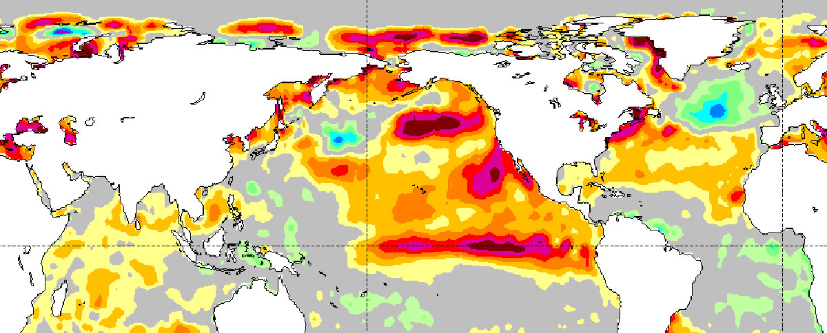
Third — and this is a big one — is that while there are many atmospheric and oceanic ENSO conditions this year that are similar to the 1997-98 El Niño, there are also some significant differences that may (or may not) affect this year’s winter. Topping that list is the vast area of warmer-than-normal ocean water off the coasts of Oregon and Washington, aka “The Blob.” While a defining characteristic of a global El Niño is the immense areas of anomalous warm water covering the eastern Pacific, scientists don’t know what will happen when this warm water meets The Blob. These three points — small sample size, a history of El Niño’s affecting southern California more than Central and Northern California, and the unknown outcomes of the Battle of the Warm Water Blobs — are why many scientists are hedging their bets about the effects of this winter’s El Niño forecast.