.jpg)
In January 2009, Bay Nature published “Taking the Heat: Bay Area Ecosystems in the Era of Climate Change,” a special report intended to “bring home” the reality of climate change, outlining the impacts global warming is having on our landscapes, shorelines, and waterways.
The bad news: In the subsequent three years, the global community has failed to reduce its carbon footprint; in fact, new reports indicate that greenhouse gas emissions are increasing, and at a faster rate than before. So we face a dual challenge of working even harder to reduce emissions (mitigation) while at the same time dealing with the impacts that are already underway (adaptation).
The good news: In the Bay Area, groundbreaking initiatives are under way to meet this challenge, many working through the Bay Area Ecosystem Climate Change Consortium (baeccc.org). “Dispatches from the Home Front” is a series of articles that will highlight this exciting work, to make it clear that, yes, the problem is real; and, yes, we can do something–many things–about it.
A wave is more than a wall of water rolling into shore. It has a height and a speed, a direction and duration. It can carry tawny plumes of silt or buckets full of sand. Waves in San Francisco Bay rarely rise to more than three feet, a pretty white chop, midget Pacific combers. But they have muscle. Enough to erode shores and crack seawalls. Enough, if combined with a high tide, a rising sea level, and the wallop of a winter storm, to roll right past San Quentin Prison into Corte Madera and San Clemente creeks, over the Greenbrae boardwalk and trailer parks, to splash on the mall wall of Nordstorm. Or even flood Highway 101 in that low spot near Lucky Drive.
Or not. A few things stand in the way. A levee here, a concrete wall there. And 210 acres of wetlands. Indeed, since last spring, scientists have been measuring everything from the depth of the bay floor to the height of waves and the elevation of Corte Madera Marsh, all so they can better understand how these softer edges of the shore might be able to dampen, or withstand, the walls of water coming our way with climate change.
“When you have sea level rise, you can look at it as a simple case of flooding over the edge of the bathtub,” says oceanographer Bruce Jaffe of the U.S. Geological Survey (USGS), one of the guys they send all over the world to study tsunamis. “But what really happens is that as the sea level rises, the Bay changes in configuration, sediment moves, topography shifts . . . That’s where we get the interesting science.”
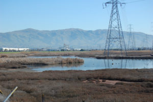
Interesting science is certainly unfolding around Corte Madera Marsh Ecological Reserve in Marin County, chosen as a test site for the new research spotlight because it’s exposed to wind waves, ringed with both historic and restored wetlands, and has a history of erosion along the marsh scarp and flooding in the creek. “If we can figure out how resilient this specific wetland is, and what it’s sensitive to, then we can get a better idea of how to manage it to retain its flood control benefits and other ecosystem services as our climate changes,” says Wendy Goodfriend of the San Francisco Bay Conservation and Development Commission (BCDC).
BCDC is the state agency charged with regulating development along the shoreline of San Francisco Bay. The agency is spearheading the $1.3 million study on wetland adaptation in the Corte Madera Creek watershed with funding from the San Francisco Estuary Partnership and in-kind matches from research partners. The hope is that data collected can be plugged into computer models to create localized sea level rise scenarios and to project impacts on wetlands and shoreline around the Bay.
A recent report from PRBO Conservation Science underscores the timeliness of going to the next level of scientific scrutiny at Corte Madera. PRBO concludes that the Bay could lose more than 90 percent of its wetlands in the next 50 to 100 years if current conservative projections of a more than five-foot sea level rise are correct. The report also notes that most of this rise will come in the second half of this century, which is why some biologists are beginning to recommend accelerating restoration activities now, while we have the time.
Results from the Corte Madera study aren’t due out till late 2012, but some of the research is starting to appear on USGS web pages. The findings aren’t just of academic interest. Planners like Goodfriend need to be able to tell people with bayshore property, paved or green, how they might adapt to sea level rise. And the planners need to back up their recommendations with good science. “One thing that’s hard about climate change research is it’s so interdisciplinary,” adds USGS biologist Karen Thorne. “We can be plant and animal people but we have to work with the marsh sediment people who then have to work with water sediment people. It gets complicated. You have to have a lot of partners, so building these large research teams is what it’s going to take.”
When the first research vessel set out to collect data in winter 2010 it wasn’t “a duck pond day,” according to USGS marine technician Mike Boyle. Rain pelted the RV Parke Snavely‘s aluminum decks. Ferry wakes bobbed the normally stable 36-foot-long catamaran on meter-high waves, as it rounded the Tiburon Peninsula and began zig-zagging across the shallows, bouncing sound beams off the bottom to map the Bay floor.
The Snavely carries enough sophisticated computer power to account for every pitch and roll and to recalibrate its bathymetry (Bay floor depth) measurements accordingly. But Boyle and colleague Dave Finlayson, who tap their on-board keyboards with the confidence of navy guys trained to hunt submarines, still seemed flummoxed: The sonar couldn’t get a good fix on the bottom. “We tried nine times and never got it right,” says Finlayson, though they did succeed on subsequent calmer survey days. Later they speculated that an amorphous “fluffy mud layer” created by freshwater input from a previous storm and a recent sewage discharge may have faked out their instruments.
Fluffy mud or not, the Snavely can boldly go where few other research vessels have gone before–into the tidal shallows of San Francisco Bay. The boat needs only about one-and-a-half meters of depth to proceed. On your average bathymetry survey cruise, Snavely skipper Jenny White spends most of her time glancing back and forth from the window to the screen on her helm, trying to steer the boat perfectly between lines set by Boyle. “I used to be a tech on Antarctic icebreakers,” says White. “I had to retrain to the small scale of bay work. It’s a whole different thing working close to shore.”
But close to shore is where all the action will be as sea level rises and tides may collude with extreme weather to produce more frequent and severe storm surges. So scientists and planners agree that accurate local bathymetry, close to shore, will be key to modeling how waves change as they traverse the shallows and marshes, and predicting the damage they may do. That’s why another Corte Madera Marsh cruise of the Snavely found USGS oceanographer Jessie Lacy stationed on the rear deck, placing tripods in the shallows between the Larkspur ferry channel and the edge of the marsh. She equipped each tripod with sensors to measure wave height, velocity, duration, and direction. Instruments also recorded tides and currents and concentration of suspended sediment–all key factors in any wetland adaptation scenario.
To place two other pressure sensors, Lacy climbed into a kayak and paddled up a small marsh creek where the Snavely couldn’t travel. As waves rolled in past each of her five sensors over the course of three months, their characteristics were recorded. In examining the data, Lacy found that wave height diminished by 55 percent, on average, as waves rolled in from deeper waters across the shallows of Corte Madera Bay. Crossing the mudflats and marsh they decreased even more. By the time waves reached the most landward pressure sensor, 150 meters up that creek inside the marsh, they were less than a centimeter tall–or for all intents and purposes, undetectable. “I wasn’t surprised by how much the marsh slowed down the waves, but I was surprised by how much the mudflat did,” says Lacy. Her results suggest that both bathymetry and marsh vegetation will influence the way future waves impact our shores.
With data from the bay side now being loaded into computer models, the tricky part will be to mesh it with data collected on the land side. Using legwork, stakes, GPS, and eyeballs, other scientists have walked the marsh to measure elevation, map topography, document vegetation and wildlife, and assess historic rates of sediment build-up.
One thing they’ve found is that Corte Madera is one of the lowest marshes around the Bay. “For the endangered California clapper rail, this means their habitat is being flooded more often, so the risk from sea level rise is higher than at other sites we studied,” says Karen Thorne, part of a USGS team tracking ground elevations and endangered species habitat in 13 marshes around the Bay. USGS added Corte Madera to its survey so it could match up its data with BCDC’s. “It’s a beautiful healthy marsh, with a lot of clapper rails,” she says. “Habitat management in the face of sea level rise gets complicated because these species are so highly tied to marshes. They’re not going to suddenly decide to go live in oak trees.”
But the rails won’t have to go anywhere if the marshes can trap enough of the sediment floating around the Bay and coming in from watersheds to keep up with rising water levels. To get a handle on this part of an increasingly complex wetland adaptation equation, University of San Francisco wetland ecologist John Callaway sank an aluminum tube into the marsh surface at six different places in the study area, pulling up 50-centimeter “cores” of sediment. He then took them back to the lab to estimate how quickly these sediments had accumulated. Now that all of the gold mining debris that clouded San Francisco Bay for more than a century is finally petering out, according to USGS, those interested in saving wetlands are looking around for other sources of this key ingredient of marsh formation. “If sea level rises and suspended sediments go down, that puts double pressure on the marshes to keep up,” Callaway says.
Callaway is measuring not only past levels of sediment build-up, but also current levels in Corte Madera Marsh and nearby Muzzi Marsh. For the BCDC study, he walked through the pickleweed and cordgrass every three months at low tide to check 48 markers that show recent deposits of sediment left by waves and tides. He found this location, like other Bay marshes, to be accumulating about three to four millimeters per year, enough to keep pace with sea level rise in the near term.
“Marshes like Corte Madera are not going to just disappear,” says Callaway. “Between the upper and lower marsh we measured about 40 to 50 centimeters in elevation change, so even if they lose some elevation each year as sea level rises, they’ll still remain marshes the next 40 years. It’s 60 to 100 years out where the marshes could really be under significant threat.”
Certainly managing a soft-edged marsh, which naturally adapts to sea level rise, appears to offer more options than managing a hard-edged seawall. So our recent investments in restoring Bay wetlands may pay off in more ways than just improving ecosystem health and endangered species habitat; it turns out they will also buy us time to make the difficult choices represented by Corte Madera’s waterfront homes, shopping mall, and nearby Highway 101. In the meantime, modeling the resilience of this particular marsh–by getting down in the water and the mud with sensors, sonar, and sediment cores–may help us stay a step ahead of the walls of water surely heading this way.


