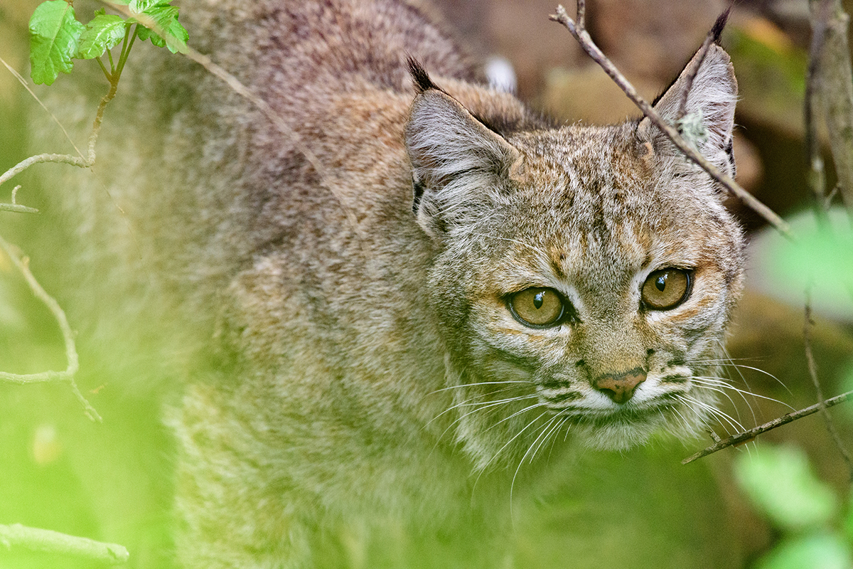
Her four paws pad softly along the golden grass of the Sonoma Valley floor’s oak savannas, her black-tipped ears alert for the approach of danger or the rustle of prey. She’s only about eight or nine months old—still a juvenile—but a young bobcat cannot stay within the range of her mother indefinitely. She must establish her own territory—find a place to hunt her own food and raise her own young. She has to venture out.
As she leaves the foothills of the North Coast Range and Sonoma Mountain behind her, she moves through a patchwork of habitats. If she walked in a straight line, she would only cover five miles to reach the Mayacamas Range on the other side of the valley. But far from traveling in a straight line, she explores some of the 10,000 acres of the valley floor. She is learning where the wetlands and creeks provide water and safe passage; where the oak woodlands give way to savannas; where the strips of concrete fill with tens of thousands of cars each day; and which human-made crossings she can sneak through to avoid a collision on the highway overhead. And she is just one among the multitude of animals making their way around the forests, grasslands, hills, and riparian corridors of Sonoma Valley—one individual in the whirl of wildlife searching for food, water, mates, and prey.
As she heads east toward the Mayacamas foothills, she encounters more driveways and houses, vineyards and roads. Occasionally, a thick, woven-wire fence forces her to double back, or she discovers a highway underpass is too inundated with water for her to slide through. In contrast to the expanses of hay-bald and oak-studded hills to the west and the slopes of forests and chaparral to the east, the valley floor is a crowded maze of human habitats. In fact, the strip of vegetation that will bring her through the valley to the Mayacamas has narrowed to less than three-quarters of a mile wide. She has reached the thin neck of an hourglass.
Whether she makes it across in the future depends on a collective human effort to keep that small passageway open.

Between the dark crevassed hills to the west and east, there’s a thread of green along the valley floor. This is the Sonoma Valley wildlife corridor as seen from a satellite. Zoom in on the satellite image and it becomes clear that vineyards and buildings abut the filament of tree cover. Two thoroughfares, Arnold Drive and Highway 12, slice perpendicularly through the corridor, breaking the patches of oak woodland, savanna, and evergreen forest into segments. This splintering of land, known as fragmentation, presents problems for wildlife: At its most extreme, it strands animals within ever-smaller islands of habitat.
The study of island biology goes back more than a century, at least to Charles Darwin and Alfred Russell Wallace, but as the human footprint expanded exponentially in the 20th century, biologists started to wonder whether nature reserves on land—when surrounded by development—could mimic the isolation of islands in the ocean. In 1975, ecologist and biologist Jared Diamond published a pioneering paper on the subject titled “The Island Dilemma.” In it he outlined six basic principles for preventing species in nature reserves from dying off, and one of them was the idea of connecting reserves through strips of protected habitat: so-called corridors.
The idea of corridors appeared elsewhere, too—in wildlife ecologist Larry D. Harris’ 1984 book The Fragmented Forest, in conservation biologist Reed Noss’ papers identifying the need to connect protected areas of Florida, and elsewhere. But by the end of the century, only a few dozen studies had been published on the subject. “It can take a while for an idea [like corridors] to sink in,” says biologist Paul Beier, one of the biggest proponents of corridor ecology. “It takes decades before people realize, ‘Oh, the landscape is fragmented! Oh, we built a national system of highways without even thinking about wildlife!’”
Beier first recognized the importance of corridors in his Southern California work with mountain lions, which he noted were traveling between protected areas to find the resources they needed to survive. In 1998, Beier and Noss published a review of corridor research and found that although studies with solid empirical data were few and far between, they all pointed to one conclusion: Corridors promoted animal movement between habitat patches.
Corridors, the research shows, allow animals to access more of their preferred habitats, which offer the resources they need to survive, like food, water, and mates. Without that access, animal populations can suffer from dwindling food stocks, competition for limited territory, and inbreeding. What’s more, wildlife with fewer options to move has fewer options to adapt to intensifying climate change.
In the last decade, connectivity conservation—the focus on connecting ecosystems through mechanisms like wildlife corridors—has come into its own. New technologies, like computer modeling and GIS mapping, have strengthened the wave of empirical evidence in favor of corridors. Ballooning land prices have incentivized environmental organizations to purchase small, strategic parcels. Meanwhile, expanding human development has made safe passage between protected areas even more crucial for wildlife survival. Now, connectivity work is being implemented on various scales all over the world, from Berkeley to Bhutan.
In a previous era of conservation, when acquiring large swaths of land for protection was the norm, the thread of green through Sonoma Valley would have seemed insignificant. But according to Wayne Spencer, chief scientist at the Conservation Biology Institute, the concept of connectivity is everywhere now. “We’re past baby steps,” he says. “We’re serious now. Connectivity is the key thing in conservation.”
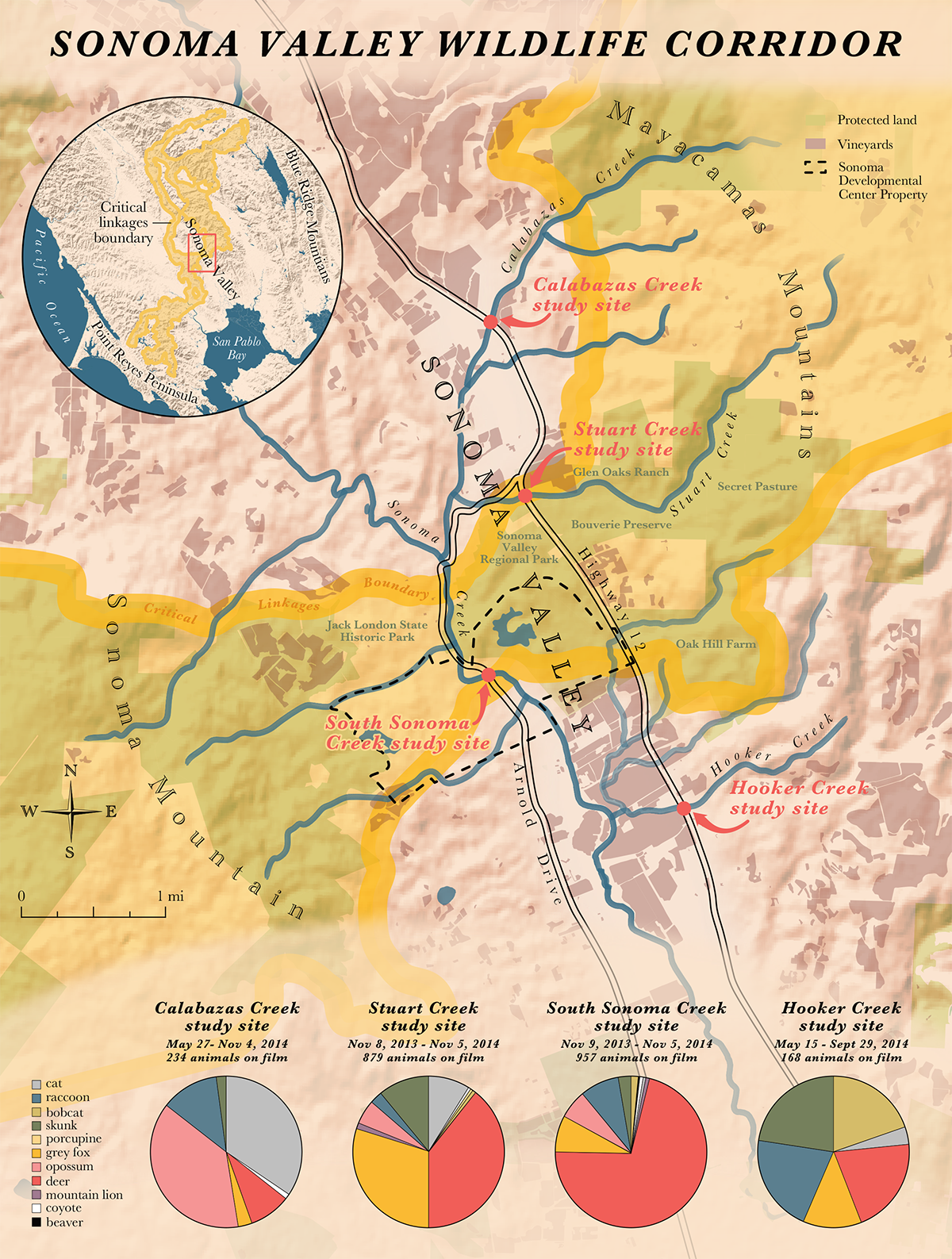
Looking at the connectivity of the Bay Area’s habitats and wildlife populations requires a landscape-scale view of conservation, and in 2010, SC Wildlands provided one in the form of a map. Laid out on the Bay Area’s nine counties were outlines of “critical linkages” that allow wildlife to move between undeveloped areas. These corridors were said to facilitate the movement of all kinds of life, including mammals, birds, amphibians, reptiles, fish, invertebrates, and even plants. The Sonoma Valley wildlife corridor was one of those linkages.
“When we saw the map of the Sonoma Valley linkage,” says Tony Nelson, a wildlife ecologist and Sonoma Land Trust’s stewardship program manager, “we immediately noticed an opportunity, and also a threat.” The opportunity lay in the 5,000 acres of permanently protected lands within the corridor.
The threat lay with several parcels smack in the middle of the corridor, which were not only unprotected, but actually for sale. One of these unprotected parcels, the state-owned Sonoma Developmental Center—with its 700 acres of open wildlands—was about to close, triggering an assessment for new land use.
One strategy for addressing that challenge was clear: Work to acquire the three small parcels of land for sale in the center of the corridor. But Nelson saw another opening for Sonoma Land Trust. While the linkages map compiled by the Bay Area Open Space Council and SC Wildlands was extensive, it was also broad. When it came down to the linkages themselves, including the corridor through Sonoma Valley, there was practically no information on the wildlife that supposedly used it. “Buying land or putting an easement on it is one thing,” Nelson says, “but when I saw that map, I thought, ‘Does anyone know how to manage these corridors? Does anyone know how to make them better?’”
When Sonoma Land Trust approached the Gordon and Betty Moore Foundation, they pitched a corridor project that included not only acquisition, but also an in-depth study of the wildlife living there. The proposed project would involve two years of assessments, including camera traps, underpass studies, biological surveys, and an advisory group that walked through the corridor. “We wanted to see if animals were moving through the corridor. No one had any data on that,” Nelson says. “So, within a month of seeing the linkages map, we sent [the foundation] a proposal.” Since then, the Moore Foundation has provided Sonoma Land Trust two grants totaling $3,915,738 for purchasing land and funding studies and improvement projects within the corridor.
In the Sonoma Valley wildlife corridor, a wild animal’s ability to traverse it can boil down to specific landmarks: whether the border of a property is blocked by an impenetrable fence, a swollen creek has blocked a wildlife road-crossing structure, a lack of vegetation forces animals to move through open exposed areas. So, while landscape-scale thinking might have sparked the connectivity conservation movement, it’s the smaller-scale wave of technology and research that’s fueling it.
“The next step is to ground-truth the linkage design with cameras and roadkill and telemetry studies,” says wildlife ecologist Tanya Diamond (no relation to Jared Diamond).
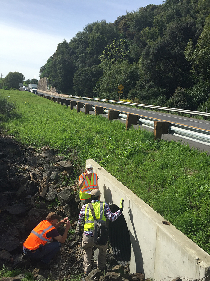
Studies like these help researchers understand where and which animals travel the corridors, Diamond says, and how to make them more usable. Along with her research partner Ahiga Snyder, Diamond developed Pathways for Wildlife, a research organization focused on wildlife connectivity. As the Sonoma Valley Wildlife Corridor project kicked off in 2013, Pathways partnered with Sonoma Land Trust on a highway underpass study and discovered a staggering amount of wildlife moving through underpasses.
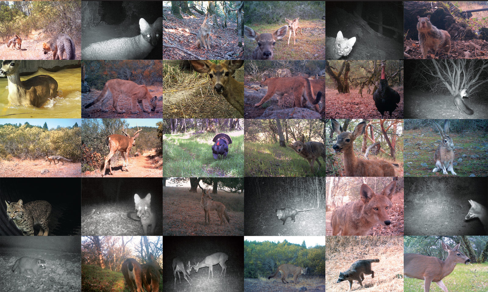
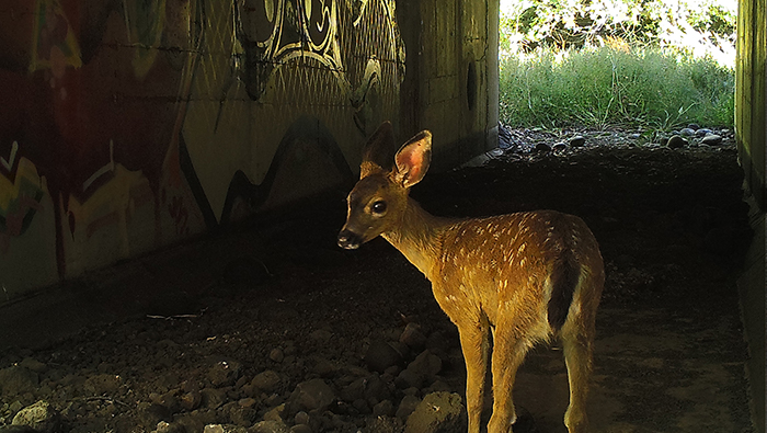
“As the months would go by and we were entering the data, we thought, ‘This is a lot of data!’” Diamond says. “And now that it’s all together, we’re just completely blown away. The amount of movement and biodiversity is tremendous.” The study yielded 8,949 detections of animals at just nine culverts and underpasses along the valley floor. Over the 12 months of the study, some of the culvert cameras provided up to 1,500 images of wildlife—each. The results reveal that practically every species of mammal in the Sonoma Valley, from foxes and deer to coyotes and bobcats, uses an underpass—or several—to cross the roads. Even species thought never to use underpasses, like river otters, were caught on camera. “We’d see these whole families traveling through,” Diamond says. “They are in stream-channel areas, but a lot of these areas aren’t by a big delta or by a big bay. I didn’t know they would cross such terrestrial places where there’s maybe only a small creek.” The river otter photos represented the first time the species had been shown to be using culverts and bridges in the Bay Area.
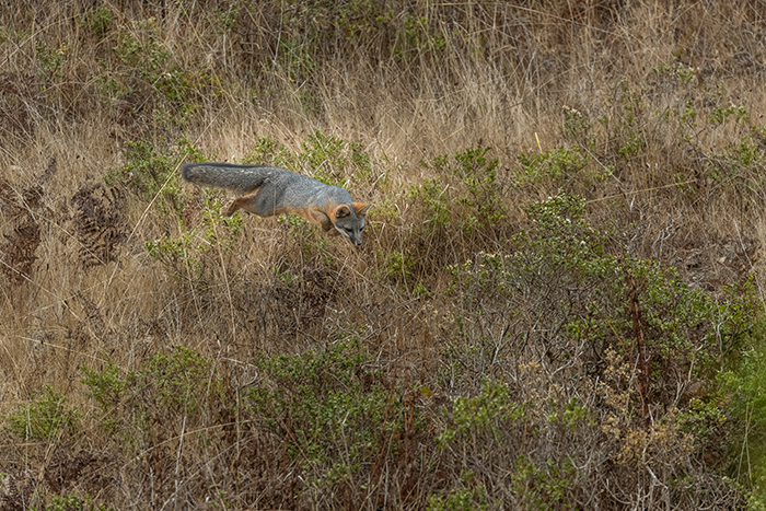
But Sonoma Land Trust’s corridor study didn’t just look at how animals crossed the highways; it also addressed the animals crossing the valley itself. A series of 44 cameras arranged in three arrays caught thousands of wildlife snapshots during the two years of the study. The animals most frequently observed were black-tailed deer, wild turkey, and western gray squirrels. But black-tailed jackrabbits, gray foxes, bobcats, raccoons, skunks, opossums, coyotes, and even mountain lions made appearances too. “We just wanted to see if there was any data that animals are freely moving through this corridor,” Nelson says of the study. “And we got that.”
The study was the first to establish a baseline of wildlife movement in the corridor, but it also revealed how each species’ movement depends on its surroundings. Gray foxes, for instance, were much more likely to be photographed in areas of chaparral rather than forest. Gray squirrels, on the other hand, were less likely to be captured in chaparral; they preferred areas with greater canopy cover.
Camera studies are remarkably powerful because they reveal movements of animals that can be largely invisible to us. When Diamond sets out to do camera studies, she often finds that people are incredulous at the placement of her cameras, saying that they haven’t seen much wildlife for her cameras to detect. “And then at nighttime, the animals are there,” she says. “It goes to show how well animals have learned to live with us. I think we have a hard time learning to live with them.”
While the corridor camera studies have captured snapshots of animals moving around the valley, a research project based at Audubon Canyon Ranch is using telemetry, via radio collars, to track the movements of individuals—specifically, mountain lions. The study shows that the corridor doesn’t just connect different animals’ territories: For one male mountain lion, the corridor is actually more central than that.
“I thought that maybe we might end up having one male [mountain lion] on the western side of Highway 12, and one on the eastern side,” says Quinton Martins, the lion project’s principal investigator. “But for [this] male, the corridor is an important part of his range. He patrols his territory, cutting through the corridor, every month.”
The fact that the corridor lies within the male lion’s territory might have come as a surprise, but the lion’s range is actually quite typical for a male in Northern California. And “typical” is quite large: His territory covers between 250 and 300 miles.
“Often, when one is in wilderness areas, one tends to think, ‘Oh, I wonder how many cats live in this area,’” Martins says. “But here, one can—one should—do the reverse, and ask: How many people live in one cat’s territory?”
According to the Audubon Canyon Ranch study, there are at least 17,000 private land parcels in this male mountain lion’s territory.
“People pass by this corridor all the time and aren’t aware of it,” says Anne Teller, owner of Oak Hill Farm. “Once you’re aware of it, it changes everything.”
Three large properties provide the majority of open wildlife habitat on the eastern edge of the corridor. One of these is Glen Oaks Ranch, a Sonoma Land Trust property. Another is Bouverie Preserve, owned by Audubon Canyon Ranch. The third is Anne Teller’s property. Oak Hill Farm spans 677 acres, though only a few dozen of these are used for farming. The vast majority of the property is untouched.
Teller has a conservation easement with Sonoma Land Trust in which she has agreed to not further develop these lands. But the trust is now working with landowners on other aspects of corridor health besides the preservation of undeveloped land. A main focus is removal of certain barriers to wildlife movement. The most obvious type is fencing. Nelson and Teller have joined forces on a fence-modification project, which involves taking out old, unused fences and investigating the use of wildlife-friendly fences where needed.
Teller’s land also flanks Highway 12; a 2016 traffic census estimated that roughly 14,000 cars pass her driveway every day. The best way for wildlife to cross the highway is through a culvert that abuts her property, and she agreed to allow the land trust to clear the blackberry bushes that were blocking access to the crossing. Oak Hill Farm also has three creeks running through it that serve as critical riparian corridors; Teller’s daughter is working to clear at least one of the creek beds for animal crossings.
Aside from removing barriers, maintaining healthy habitats is key. Oak Hill Farm plants hedgerows with native vegetation in order to better mimic animals’ preferred habitats. As the camera studies showed, wildlife can be particular about the habitat type they will use to cross the valley. “What we’re finding,” Martins of the mountain lion study says, “is that it just has to have the right habitat.” Sonoma’s native habitat types—chaparral, oak woodland and savannas, grasslands, evergreen forests, and wetlands—provide homes and sustenance for all kinds of wildlife, “whether it’s in a regional park, or a preserve, or private land doesn’t really matter,” Martins says.
Sonoma Land Trust points to the efforts of Oak Hill Farm as an example of private landowners who nurture native habitats with few barriers to movement. The changes might be small—planting a hedgerow here; taking down an old fence there; clearing a blackberry bush or two—but when enough landowners undertake them, they can be vital. “I think [corridor management] has to be a consortium of private and public efforts,” Teller says. “No one person or organization can do this alone.”
As the connectivity of landscapes comes to the forefront of conservation work, so has an entirely different type of connectivity. “All of our projects have multiple partners. All the land trusts not only are working with each other, but we’re all working with Caltrans or the local transportation authorities,” Diamond from Pathways for Wildlife says. “The multi-partnership has been so powerful.”
Given the number of institutions, organizations, and people within the Sonoma Valley corridor, cooperation is mandatory for achieving what’s known as permeability—the ease with which animals can pass through a landscape. The partnerships have already proved fruitful. The results of the underpass study have sparked a conversation between Sonoma Land Trust and Caltrans on improving wildlife crossing structures throughout the corridor. And private landowners like Teller are starting to implement changes that make their properties friendlier for wildlife. Even public lands are under assessment. A research team from the Wildlife Conservation Society is working with Sonoma Land Trust to study the effects of recreation on the corridor.
In a place like the Bay Area, where the population is both active and increasing, human recreation on public lands can significantly impact wildlife. Sarah Reed, the lead researcher for the Wildlife Conservation Society team, has found that in the North Bay, the mere presence of hikers, bikers, and equestrians in protected areas can lead to a fivefold decline in detections of coyotes and bobcats there. Such declines can be detrimental to species survival if land use isn’t managed properly.
But people recreating in the corridor can help. “Anyone who visits the area has a role to play,” says Reed. The public’s interest in and love for the area especially matters when it comes to the Sonoma Developmental Center (SDC)—the state-owned care facility, in the heart of the corridor, that will close at the end of 2018. Currently, development on SDC is limited to a small campus of stately buildings set on tidy lawns, which represent just 200 of the more than 900 acres of the property. But this could change. “If we lose [SDC] to development, the corridor shrinks down to a very narrow regional park,” Nelson says, “and a lot of the permeability value of this entire corridor will disappear.”
Luckily for the corridor, however, a partnership of people and organizations is advocating to maintain the undeveloped land on the property. As the state conducts its property assessment and looks for public comments on future uses for the land, people have been pointing to the importance of the open space for wildlife movement. “It’s been really heartening and exciting to see the public’s support for the corridor,” Nelson says.
In conservation work, it’s not uncommon to scramble for public support only after a property is at risk for development. “But in this case, we’re not playing catch-up,” Nelson says. “Because of the corridor study and the outreach we’ve done, we already have support; we have a coalition ready.”
These days, Sonoma Land Trust has its sights set on the conservation of an even larger landscape corridor, from Marin to Napa County. In fact, connectivity conservationists around the globe are expanding the sizes of the corridors they advocate for. Bhutan is looking to connect most, if not all, of its national parks, which would make it the first nation with more than half of its territory under protection. In North America, land trusts are signing conservation easements to strengthen a corridor between Yellowstone National Park and the open spaces of the Yukon in northern Canada. And in his recent book Half-Earth, biologist E.O. Wilson advocates for corridors that cross continents. “Now, our work is not just on ecological connectivity,” says Spencer, of the Conservation Biology Institute, “but human network connectivity.”
Regardless of a corridor’s scale and size, the benefits are felt individually and locally, in an extended tree canopy for a squirrel, an open underpass for a family of otters, or a section of fenceless oak savanna for a nine-month-old bobcat making her way through a fragmented landscape.
Wildlife Travel By Corridor was produced by Bay Nature magazine with the generous support of the Sonoma Land Trust for publication in the April-June 2018 issue of the magazine. Additional copies of this publication can be obtained by contacting Bay Nature (baynature@baynature.org) or Sonoma Land Trust.
Sonoma Land Trust believes the land is the heart of the community. Since 1976, the nonprofit Sonoma Land Trust has protected more than 50,000 acres of scenic, natural, agricultural and open land for future generations, and is accredited by the Land Trust Accreditation Commission. For more information, please visit sonomalandtrust.org.

