The Pacific Coast north of San Francisco is justly renowned for its scenic beauty. It is also geology writ large, where evidence of powerful forces still at work on our region is exposed at many places. Goat Rock State Beach on the Sonoma Coast may be small in acreage, but not in what it offers in the way of scenery and geology. Lying just south of the mouth of the Russian River, Goat Rock Beach has white-capped waves, sea stacks, marine terraces, a natural bridge, sand dunes, a fine exposure of our state rock—serpentinite—and evidence of active tectonics shaping the landscape over hundreds of thousands of years. Goat Rock itself is a flat-topped sea stack, one of many that rise above the waves like sentinels guarding the shore. The flat top is a legacy of eroding cliffs and crashing waves from long ago.
If you come to Goat Rock Beach from Bodega Bay along Highway 1, you meander over a wide, almost-level bench at the edge of the sea, cut here and there by stream channels. What has created such a flat surface in an otherwise hilly landscape? The answer involves a surprising number of geologic processes.
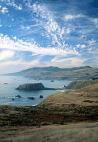
- View of Goat Rock from the south. Photo by David Weintraub
The flat bench is a marine terrace, a surface carved long ago by the action of waves at sea level and later uplifted to its present position. Waves, washing ceaselessly back and forth where land and ocean meet, grind up the underlying rock and erode back the cliff face. Over time, the waves carve a gently sloping surface along the shore, called a wave-cut platform. As rocks tumble off the cliff to the water’s edge and sand is carried in with the tides, most such platforms become buried by sandy or gravelly beach deposits. But along some shores, you can see the wave-cut platform just offshore at a low tide. Duxbury Reef at Bolinas, some 50 miles to the south, is a good example.
Where the land along the coast is rising, as in parts of the Bay Area, wave-cut platforms with their overlying sands are uplifted; they are then called marine terraces. The one on which Highway 1 meanders is over 100 feet above sea level, well away from the pounding waves that formed it. Measurements of coastal uplift in the Bay Area indicate that the land is rising at a rate of about one to three inches a century. Although this may seem very slow, even fractions of an inch per year, operating over a long period of time, can make major changes in the landscape. As the coast is uplifted over hundreds of thousands of years, wave-cut platforms are raised from sea level to elevations of hundreds of feet. Meanwhile, new platforms are being created at sea level. Each successive terrace is (usually) both higher and older than the next one. Uplifted marine terraces can be found in most coastal counties: Half Moon Bay in San Mateo County sits on one; so does Sea Ranch in northern Sonoma County. At some locations on the Peninsula, south of San Francisco, five or more flights of terraces can be seen rising, in stair-step fashion, up the hills to the east. Above Goat Rock, the higher terraces east of the highway are more deeply eroded and less clearly defined than those on the Peninsula.
To get a sense of this uplift, pull out at the second small turnout on the left as you drive into Goat Rock State Beach; look south over the marine terrace just below you. Or walk out to the small knoll for a better view (keep to the left; the righthand trail goes down to the beach). Perched on top of the terrace is a large rock, floating like a ship on the level terrace surface. To understand what it is doing there, look out to the present-day shore. In the surf, at the water’s edge, is a similar massive rock, rising above the modern-day wave-cut platform. It is a sea stack, a rock composed of more resistant material than the weaker, more easily eroded rock that once surrounded it. Here, the shoreline used to extend much further to the west, several hundred feet beyond the present cliffs. Look at the sea stacks just offshore from the beach and at the mouth of the Russian River to the north. Now, mentally fill in the seascape between the stacks and the current shore to put the land back where it was centuries ago. This exercise provides dramatic evidence that the edge of the continent is consumed by the sea at an astounding average rate of one to three feet a year along the central California coast. “Average” is the key word here. Little erosion may take place for several decades; then 50 feet of shoreline may fall into the sea during one winter of major storms.
When a wave-cut platform is uplifted, its sea stacks go up in the air with it. From a vantage point just south of the Goat Rock entrance, you can see at least three generations of sea stacks: those on the present wave-cut platform at the water’s edge; the one on the terrace just below the highway to the west; and to the east of the highway, a number of large rocks that were sea stacks on the still higher terraces.
Flat-topped Goat Rock was once a sea stack connected to land by a sand bar. Such a bar of sand or gravel that connects an island, even one as small as a sea stack, to land is called a tombolo. The Goat Rock tombolo used to be underwater at high tide, turning Goat Rock into an island and a proper sea stack. The tombolo has since been turned into a parking lot, and now you can climb right onto Goat Rock at any tide.
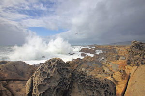
Sometimes the vigorous attack of ocean waves breaks up the rock at the base of a sea stack to form a cave or natural bridge. You can see one of these, Arched Rock, along the shore as you drive to the beach parking area. Pillars of foam spout up high into the air as waves crash through the arch. Decades—or perhaps centuries—from now, the bridge will collapse under the onslaught of these waves, creating two companion sea stacks.
The sea stacks along the coast here are composed of rocks belonging to the Franciscan Complex, formed during a time of plate collision along the west coast of North America. From about 200 to 30 million years ago, the North American plate was colliding with the Farallon Plate (predecessor of the Pacific Plate). A variety of rock types were formed during this dynamic process, including pillow basalts (former ocean crust), cherts (see Bay Nature, Winter 2001), marine sandstones called graywacke, and several others. During the plate collisions, these rocks were greatly faulted and sometimes crushed into melange, which is a mixture of ground-up matrix and resistant lumps of rock floating in it, like a chocolate pudding with bits of marshmallows, walnuts, and raisins. When melange at the coast is struck repeatedly by the waves, the matrix is easily washed away, leaving the more resistant blocks standing in the ocean as sea stacks. Goat Rock is a block of resistant graywacke. The other sea stacks here are formed of various Franciscan rocks. The former sea stack on the uplifted terrace south of the entrance road is eclogite, a metamorphosed basalt.
More evidence of Goat Rock State Beach’s dynamic tectonic past is revealed in an impressive cut in the cliff along the road to the south parking lot by Goat Rock. Here you can see a fine exposure of blue-green serpentinite, California’s state rock. This is rock that came up from the mantle of the earth—over five miles below the surface—when the Farallon Plate was colliding with the North American plate, forced up by the tremendous pressures generated by this massive collision. The glitters of light that reflect off mirror-smooth patches of the serpentinite point to the powerful forces at work. These polished and grooved surfaces—called slickensides—were formed as the serpentinite was squeezed up from deep in the earth, rock grinding on rock. Softer rock was crushed in this process, while harder, more resistant rock became polished. Here, in the cliff, you can see the result: rounded, resistant serpentinite blocks surrounded by crushed serpentinite.
At this delightful spot on the Sonoma Coast, you can contemplate the many dynamic geologic processes that form the landscape of our Bay Area shores—from the almost unimaginable forces of plate collision to the ceaseless attack of ocean against land. Sit on the beach, feel the pounding waves, and imagine yourself riding the continuing coastal uplift that, millenia hence, will turn this beach and its underlying platform into a marine terrace, with Goat Rock a sentinel sea stack perched high above the waves and the new beach forming below.
Getting There:
Take Highway 1 north from Bodega Bay or south from the Russian River and Jenner. Goat Rock State Beach is the first turnoff south of the Russian River on Highway 1.

.jpg)


-300x163.jpg)
-300x179.jpg)
