Plate tectonic processes are fundamental to the geology of the Bay Area. Every aspect of our landscape—the hills and valleys, the Bay, the underlying rocks—is affected by our presence at the active boundary between the North American and Pacific tectonic plates. Present and past tectonic activity along the Bay Area’s many faults has bent and broken the crust, uplifted it in one place, dropped it down in another, rearranged rocks, and even allowed molten rock to seep up through fractures in the crust to produce volcanoes. All these processes have contributed to the rich and varied landscape of the Bay Area.
Movement over a long period of time along the strike-slip faults of the San Andreas Fault System has produced many of the common features of our local landscape: linear valleys, uplifted or down-dropped blocks, offset streams, fault scarps, and sag ponds, to name just a few. Strike-slip faults can also have a component of vertical movement, especially where they bend. Local conditions- including rock type and proximity to a fault-all interact with tectonic movements to form the landscapes we see around us.
Here we take a look at just a few of the region’s familiar landscape features that are formed by active tectonic movements along the Bay Area’s faults.
Linear Valleys: Tomales Bay
Among the most prominent and easily recognized landscape features caused by strike-slip faulting are linear valleys, such as the San Andreas Fault valley on the Peninsula. The valley pictured here that separates Point Reyes from “mainland” North America—and is partially filled by Tomales Bay—is another. As the sides of a strike-slip fault move past each other, the rocks along the fault are ground into fine bits, allowing them to be more easily washed away. Over time, this process of grinding and erosion along the fault forms a valley. As sediment erodes off the hillsides on either side of the valley, it accumulates on the valley floor. Finer sediment settles in the lower spots, partially sealing the surface and allowing the water to collect rather than seep into the ground. Such small water-filled depressions are called sag ponds. Lake Temescal in Oakland and Lake Elizabeth in Fremont are sag ponds, created by action of the Hayward Fault, that have been dammed and enlarged for water storage and recreation. Larger bodies of water, such as San Andreas Lake north of Crystal Springs Reservoir, are also common in fault valleys.
- Herb Lingl, www.aerialarchives.com
Tectonic Basin: San Francisco Bay
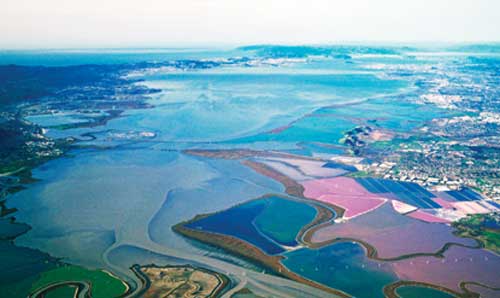
San Francisco Bay, the most prominent and important geographic feature in the Bay Area, also owes its existence to active faulting, although not to the grinding action that creates linear valleys like those filled by Tomales Bay and Crystal Springs Reservoir. Moreover, the valley flooded today by the Bay is not a river valley, carved by the flow of water over thousands of years, although rivers have flowed through it when it was a dry valley, during periods of lower sea levels. Rather, it is a tectonic basin, a down-dropped lowland formed perhaps one or two million years ago as a result of vertical movement on the San Andreas (several miles to the west) and Hayward (a mile or so to the east) Faults. The lowland continues northward to Santa Rosa and south to San Jose and Silicon Valley. Cores drilled into sediments beneath the Bay show that it was first flooded by ocean waters perhaps a million years ago. Bay waters have come and gone several times since then as sea level has risen and fallen in response to global climate changes. The present San Francisco Bay is surprisingly young, only about 10,000 years old, formed as the last ice age ended, raising sea level around the world and flooding the former valley that now constitutes the geographic and geologic centerpiece of this dynamic region.

- Photo by John Karachewski www.geoscapesphotography.com
Hills and Valleys: Marin County
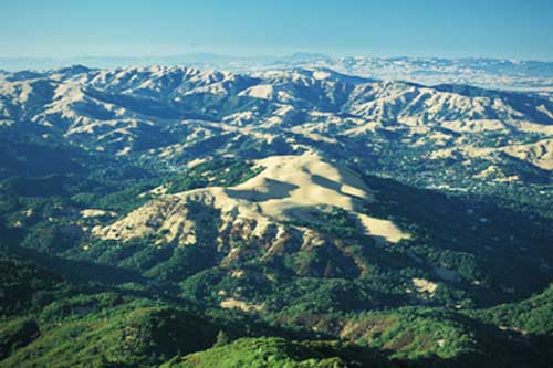
In addition to strike-slip motion, fault movement in the Bay Area contains an element of convergence or transpression—the squeeze play between the Pacific and North American Plates. Even though it represents only about 10 percent of the relative motion between the plates, transpression exerts a large impact on Bay Area landscapes by shortening the crust through folding and faulting while also increasing uplift. Many of the Bay Area’s hills and valleys are wrinkles in the crust formed by transpression, like the folds created in a tablecloth when you push the edges together. Not all the Bay Area’s hills trend in the same direction because local conditions and other types of fault movement may affect the way in which compression wrinkles the crust.
Here, in a view north from Mount Tamalpais in Marin County, you can see the effects of both transpression and erosion. Transpression is uplifting Mount Tam, and it has folded the long ridges and valleys in the middle distance, which lie roughly parallel to the northwest-southeast trend of the San Andreas Fault to the west. The rocks that form the ridges are more resistant to erosion, while the prominent hill in the foreground is actually the result of erosion-landslides that have flowed off Mount Tam as it rises.

.jpg)

-300x96.jpg)
-300x300.jpg)
