It is green in the Mayacamas Mountains this spring, says Lisa Micheli, the president and CEO of the 3,200-acre nonprofit research reserve Pepperwood, but it is not the kind of lush green she would like to see in March. The North Bay landscape reflects an exceptionally dry winter. It remembers the wildfires that have burned through Pepperwood twice in the last four years.
Like people living and working everywhere in California’s fire zones, Micheli looks out the window at the beginning of a subdued spring bloom and wonders: in another six months or so, when the Bay Area reaches the dry peak of its long, rainless summer and fall, what is that landscape going to remember of water? To answer that question, she says, is to begin to understand fire and water together as a year-long relationship. “What’s the landscape’s memory of rainfall,” Micheli says. “How long does the rainfall reside and where does the rain go over time?”
The relationship is not so straightforward as a dry winter leading immediately to a catastrophic fire season. The 2017 North Bay fires followed an exceptionally wet winter and a record-breaking fall heat wave. The 2020 lightning fires followed a very dry winter but started in a freak ignition event, a summer lightning storm nearly unprecedented in Northern California’s recent memory. A long, hot summer and fall following a wet winter might result in a more flammable landscape than a mild, foggy summer following a dry winter.
Those are some of the caveats against predicting a bad 2021 fire season ahead. But still, scientists and land managers say, a second dry winter in a row isn’t good news for the upcoming fire season.
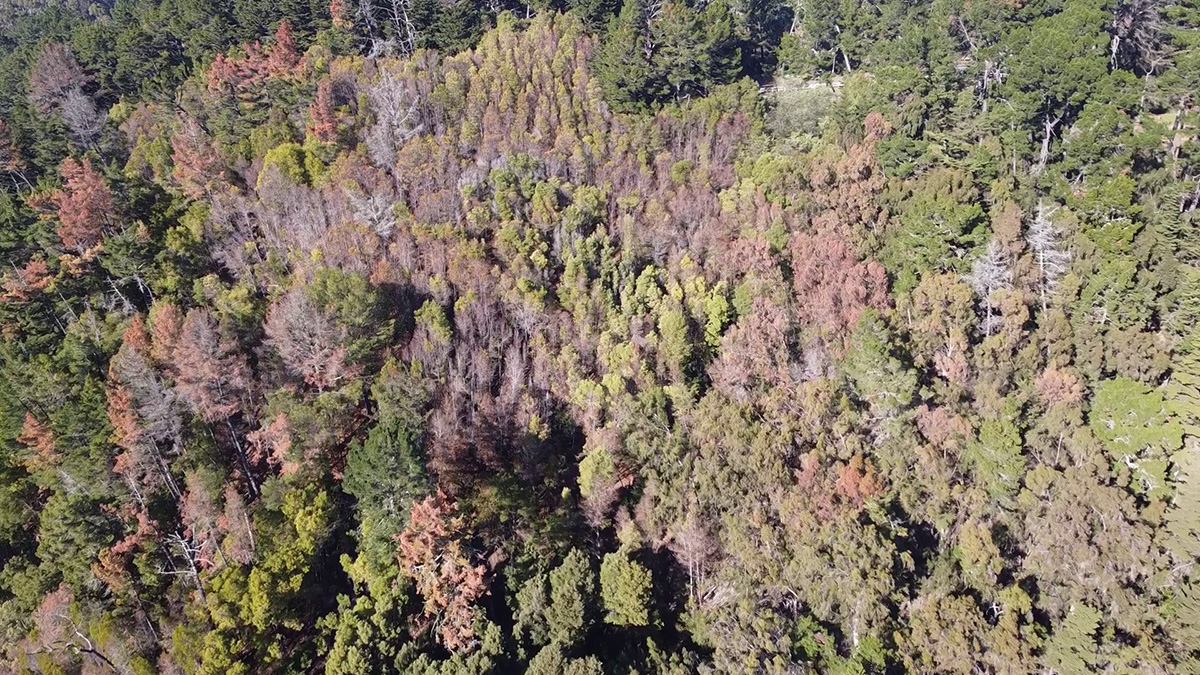
Much of California is experiencing one of the driest two-year stretches on record. With three months left in the July-June rainfall year, San Francisco has missed out on a full year’s worth of rain in the last 21 months, Golden Gate Weather Services meteorologist Jan Null points out. Dry winters result in an increase in dry and dead plants, and dry and dead plants burn readily. In the East Bay hills, where a tree dieback has damaged or killed several species of trees this winter, East Bay Regional Park District Fire Chief Aileen Theile said the District is “alarmed” at thousands of acres of “dead, standing and highly flammable tree species. They’re right in the middle of the urban interface of the East Bay.”
Though scientists are still trying to determine the exact cause of the dieback, and have identified a fungal pathogen that appears to be attacking acacia trees, even the diseased trees probably got sick because they were drought stressed to start with. “We want to know the why, but as fire season approaches, the why is starting to be less important,” Theile said. She said the District has asked CalFire for funding to help safely remove the trees.
The bigger picture, Theile said, is that climate change means a California fire crew doesn’t get the summer off no matter what happens in winter.
“Every year is a danger,” she said. “It really is.”
UC Berkeley forest ecologist Patrick Gonzalez said human emissions have raised fire risk levels everywhere over the last few decades. Average high temperatures in the Bay Area have increased by 1.4 degrees Celsius since 1895, and average minimum temperatures have increased by more than 2 degrees C. Between 2000-2018 the Southwestern United States suffered through the worst drought in the United States since the 1500s, with climate change to blame for half of the drought’s severity. Warming and other climate impacts have contributed to the area burned by wildfires doubling since 1984. The length of the dry season also appears to be increasing, a team of scientists led by Jelena Luković of the University of Belgrade reported in February in the journal Geophysical Research Letters. September, October and November rain has decreased statewide in California, and the average start of rain in the fall has been delayed 27 days since 1960, the article reports. The delay pushes the very driest part of California’s dry season into the peak of offshore wind season.
There are wet and dry years within the long-term trend, but there are no years, anymore, when firefighters rest easy.
“You’re focusing on this season,” Gonzalez said. “But the context is one in which human-caused climate change has altered ecological conditions leading up to this season.”
Still, if we focus on this season, and this particularly dry winter, and what it means for this upcoming summer and fall, we come back to Lisa Micheli’s question. Right up until the first widespread rain of the fall, six or seven or eight months from now, what will the landscape remember of water?
There is another way to phrase this in thinking about fire, which is: when does it become dry enough to wilt or kill a plant? It takes the right kind of fuel to spread a major fire. A grass fire poses far less danger than a fire in the forest canopy, and a fire needs help to get into the canopy. The soil has to be dry enough to compromise the trees, or the winds have to be dry and gusty to fan a fire upward, or the ground has to be thick with so-called “ladder fuels” that let fire climb from grass to leaves. So when has it been long enough since the last rain that the March landscape of green grass, brush and forests become a landscape of fire fuel receptive to a spark?
As one way to measure fire risk, CalFire crews take samples from vegetation around the state to check the “live fuel moisture,” the amount of water in living plants. CalFire Battalion Chief Jon Heggie compared the landscape to a dishwashing sponge. If you wash the dishes the night before, and grab the sponge in the morning, it’s still damp. Leave it alone for a week and it’s “bone dry.” “The vegetation when it’s drought stricken is just like that sponge after a week vacation,” Heggie said. “Now, with this back to back [dry winters] and a decade of droughts, more than a decade, then we’re still reeling from that. When the vegetation dies it doesn’t come back. It’s dead fuel.”
A plant has to pull off a paradox when it comes to water. It needs to first of all create the conditions inside of itself that cause water to flow into its roots and up its stem into its leaves. Scientists call this “water potential,” or the potential for water to move from one place to another. A plant has to have negative water potential relative to the soil in which it grows. The more the soil dries out, the more the plant has to decrease its own water potential. But the plant must simultaneously maintain pressure within its leaves, called “turgor,” to push out against the atmosphere and hold its shape.
It does this by loading its leaves with salts that decrease the water potential even more, thereby sucking water into the leaves to create positive pressure. A “nice trick if you can do it,” wrote UC Berkeley plant scientist David Ackerly, who patiently explained all this to me by email.
I have been picturing this transpiration cycle and turgor as something like Atlas in Greek mythology, whose job was to hold up the sky. Atlas has to push upward to keep the universe from collapsing — positive pressure. But he also has to suck in his stomach, and tighten his core, to create the strength to shoulder the burden — negative potential.
So here’s what happens when the rain dries up. The plant passes the water from the ground up to its leaves and then exhales it as water vapor, a process scientists call transpiration. The warmer it gets, the more water the plant loses to the atmosphere and the more water it demands from the ground. But the drier the soil gets, the more negative water potential in the soil. At some point, the plant simply cannot get the water it needs anymore. It loses its ability to keep up positive pressure. Atlas’s gut collapses. The now-wilting leaf can no longer push up against the sky, causing sadness in botanists and Peloton instructors alike.
The “wilting point” is the name for that point where there’s no available water left in the soil, and the plant dries out, wilts, and starts to die from the leaves down. In the firefighting parlance, its live fuel moisture plummets. The plant is ready to catch and spread fire.
Many plants can recover from reaching their wilting point, and the actual point differs from plant species to plant species. Agricultural plants, used to soft lives in well-watered fields, are “pretty wimpy” when it comes to wilting point, Ackerly wrote. Many California native plants, accustomed to summers and falls where it does not rain, are tougher: able to operate in lower water potentials, able to dig down deeper to where water persists, able to survive and then recover once (or if) the rains return.
We have reasonably good maps of what plants live where, but scientists still have very little ability to predict where and when and how often plants reach their wilting points in the wild, and so pinpoint the areas where lack of rain translates to immediate fire risk. It is, essentially, a question at the intersection of individual plant personality, landscape type, and how long the land remembers water.
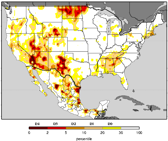
That’s a question Lorrie and Alan Flint, scientists with the US Geological Survey who work often with Micheli and Pepperwood, have tried to solve. In 2014, they published a model of the “climatic water deficit,” the difference between how much water the landscape could potentially be losing to plants and evaporation and how much water the landscape is actually losing. The model offers a kind of specific map of where plants are drying and becoming fuel, and so shows how a season’s rainfall and temperature contribute to fire risk.
Climatic water deficit helps understand a drought beyond whether reservoirs are full or not. In 2016, following three years of severe drought, North Bay reservoirs started to recharge in an average winter. By 2017, they were full, the beginnings of a surplus that has carried over even into 2021. But the landscape lagged behind. Climatic water deficit maps showed parts of the state carrying deficits well into 2017. In parts of the Russian River watershed, the Flints wrote in an article in the journal Ecological Processes in 2018, the reservoirs were full while the landscape still needed three years of normal rain to recover. The drought stresses were continuing to accumulate even after the “drought,” for human water users, had ended. Many of those drought-stressed areas burned in the 2020 LNU Lightning fires.
“The soil type, overlaid by climate, definitely does dictate the likelihood of reaching that dry-out point, that wilting point,” Lorrie Flint said. “And as it continues to dry the plants get crispier and crispier.”
Working from their den during the pandemic, Lorrie Flint said, she and Alan Flint developed a map of climatic water deficit in 2019 across the United States. At a very rough scale, she said, it overlapped with where fires burned in 2020. They’re working now on getting down to details: climatic water deficit on the scale of a few meters, which might help translate the question of where winter rain didn’t fall into where summer fire will.
The climatic water deficit idea also shows how California’s 2012-2015 drought seeded future catastrophic fire seasons. Those record-dry winters didn’t directly yield record fire summers in the same calendar year. But they pushed soil moisture to the lowest level in 1,200 years, Gonzalez said. Some plants died quickly. Many of the trees took years to die: stressed by soil water deficits, they fell on longer time spans to beetle infestations and pathogens. By 2018, scientists estimated that nearly 150 million trees had died in the Sierra Nevada, with an estimated 62 million dying in 2016, the last year of the drought. In a 2019 article in the journal Forest Ecology and Management, scientists observed a time lag between the severest parts of the drought and the greatest number of trees dying.
“Although there is little landscape-level fire behavior research to draw on, increased connectivity of heavy dead fuels over hundreds to thousands of hectares associated with rapid and extensive tree mortality events likely will increase future fire spread rates in [frequent-fire] forests,” a team of scientists led by UC Berkeley fire researcher Scott Stephens wrote in the journal Bioscience in January 2018.
The warning proved prescient: 2018 became the largest wildfire season in California history to that point, with 1.6 million acres burned, and was then surpassed by 2020, when 4.3 million acres burned.
So it is not so straightforward as dry winter equals bad fire summer — immediately. Heggie, the CalFire Battalion Chief, said the agency is watching but ultimately it’s too early to make predictions yet. Theile, the East Bay Regional Park District fire chief, and Gonzalez, the UC Berkeley forest ecologist, emphasized that individual years are blips in a long-term climate-change-fueled trend toward greater fire risk. Flint said that there may have been so little rain this season that there won’t be as much plant growth to turn into fuel later on, and that the Sierra snowpack is in better shape to provide summer water than it was in many of the 2012-2015 drought years.
At Pepperwood, Micheli says, they’ve seen that climatic water deficit correlates with live fuel moisture, but on a time lag. A group of researchers who work at Pepperwood on a project called the Terrestrial Biodiversity Climate Change Collaborative or TBC3, hope that by studying evapotranspiration and water deficits in different types of forest conditions, they can start to understand where and how water persists in the environment. Micheli said she hopes that one day scientists and land managers can develop a fire hazard index that takes into account the various effects of drought and dry soils and dry vegetation, plus distance from roads and difficulty of fire suppression, to create a daily map of where we should anticipate fire danger being highest.
“In the short time we’ve had this 10 year collaborative, we’re all aware the fire was going to be the most radical mechanism of change, and the hardest one to predict, and now here it is upon us,” Micheli said. “Some places were way drier in the landscape than others, and those will be more hazardous. How do we get a model for today, for this week?”

