As the climate warms, changes in sea level won’t occur equally around the world—some areas will see a greater increase than others. In the Bay Area, the future of sea level rise is closely tied to the melting of the vulnerable West Antarctic ice sheet.
To understand the significance of the West Antarctic ice sheet to California, we first need to grasp what contributes to sea level rise. Two related factors are at work—global mean sea level (GMSL), which is affected by the volume of ocean water distributed across the globe, and relative sea level (RSL), which is driven by local changes in sea surface and land elevation. Global mean sea level increases as warming ocean water expands and ice resting on land (i.e., mountain glaciers and ice sheets) melts, adding large amounts of water to the sea. Over the past century, expansion of the warming ocean water has been the primary contributor to GMSL and is well understood. In the past decade, the melting of ice sheets and mountain glaciers has accelerated and now dominates the changes in GMSL. Unfortunately, the connection between global climate and the melting ice sheets is not straightforward.
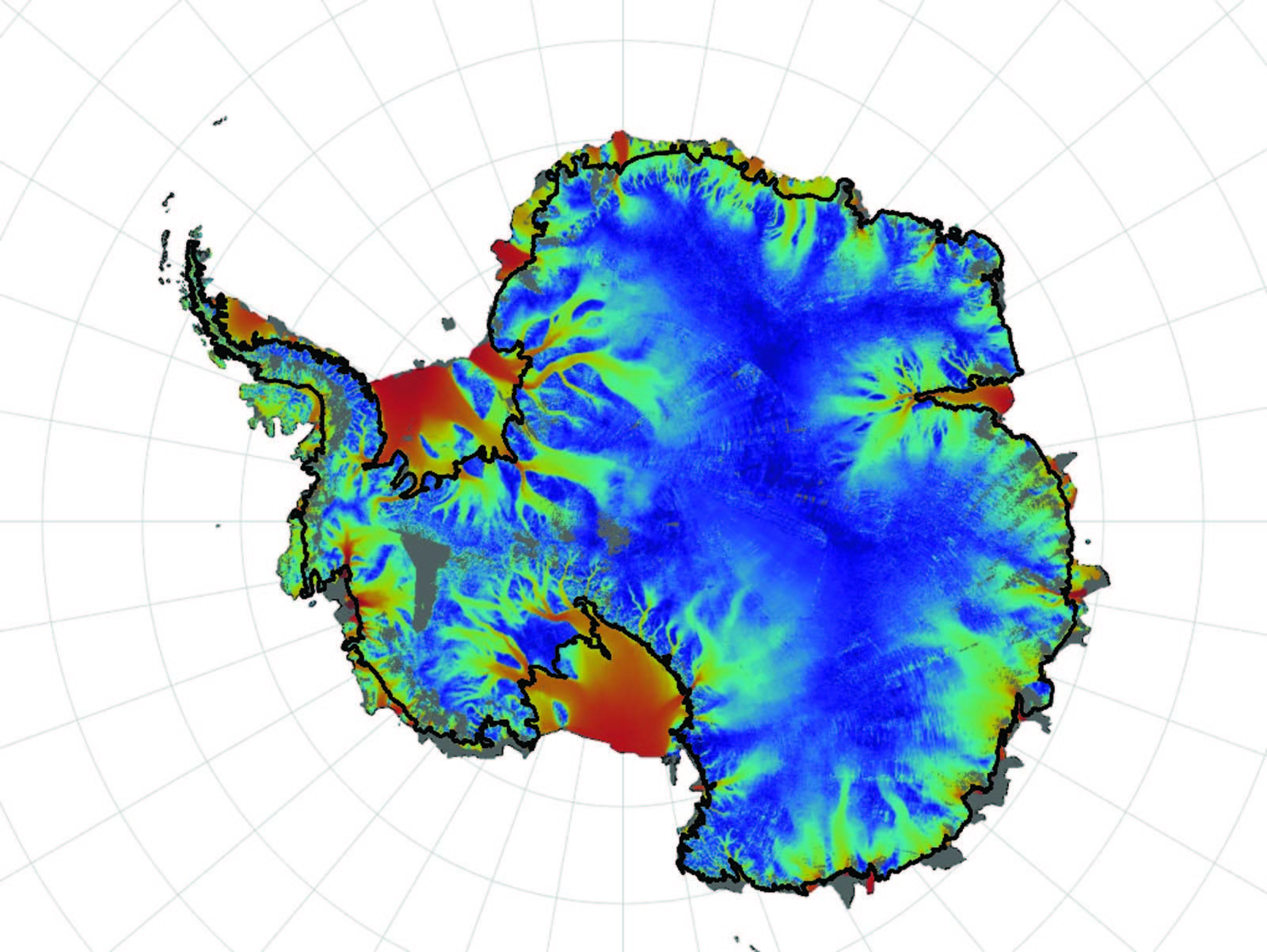
The polar ice sheets store enough water to raise the sea level (GMSL) by hundreds of feet and are melting in complex and varied ways. Perched atop land, the Greenland ice sheet measures half the size of the contiguous United States and is largely melting like an ice cube left outside on a hot day—from the outside inward. This suggests that the Greenland ice sheet will melt slowly over centuries to millennia. However, the Antarctic ice sheet is a different matter. Much of the West Antarctic ice sheet is comprised of large rivers of ice flowing from the ice sheet’s interior to the coast where large icebergs are generated. (See map.) These processes are dynamic and efficient at melting ice and able to evolve quickly, as compared to the ice sheet in Greenland. Individual rivers of ice, called ice streams and outlet glaciers, can reach the size of New Hampshire and flow up to 10 feet per day, transporting vast quantities of ice into the sea. These flow processes introduce the potential for the sea level to rise over decades to centuries, rather than millennia.
Significant uncertainties remain about the physical mechanisms controlling the fast-flowing ice and the processes by which icebergs calve off the margins of the continent because the underlying processes are challenging to observe and predict. For example, water lubricates the contact between the base of the ice and underlying earth, impacting the speed of the flowing ice. Understanding the physics of this contact requires studying processes, occurring under miles of ice, that vary over an area the size of the United States, and in a region that has not been extensively studied for very long. We’re improving our understanding of these processes quickly by connecting novel observational techniques—such as satellite observations and airborne radar—with computer climate models that predict ice sheet behavior.
Susceptibility of the California coast to sea level rise is intrinsically tied to the vulnerable West Antarctic ice sheet through an unintuitive consequence of physics in the Earth system: Sea level does not change uniformly across the globe. The vertical motion of tectonic plates, ocean currents, and the gravitational pull of massive objects affect relative sea level (RSL) locally. This concept is similar to our experience of daily tides, with the moon causing the sea surface to rise and fall locally. A similar process makes the melting of the West Antarctic ice sheet particularly alarming for the California coast. Melting of large, polar ice sheets reduces the gravitational pull of these massive bodies on local oceans. The reduction in gravitational pull causes the RSL to drop near the melting ice sheet, and this displacement causes oceans elsewhere to rise correspondingly. Gravitational effects from the melting of the Greenland ice sheet cause maximum sea level rise in the southern hemisphere. For the vulnerable West Antarctic ice sheet, the corresponding maximum RSL takes place off the Pacific and Atlantic coasts of the United States. As a result, sea level rise in California is especially tied to the rate at which the West Antarctic ice sheet melts. We expect it could more than double sea level rise estimates.
While uncertainties associated with the melting ice sheets are notable, this shouldn’t paralyze decision makers and stakeholders. Instead, our evolving understanding should underscore the necessity of building and maintaining nimble coastal mitigation strategies that can incorporate improvements in predictions and observations. Various California government agencies are leading the way, through the periodic “State of California Sea-Level Rise Guidance Document” report, which provides an avenue for the latest science to be incorporated in stakeholder discussions.
To read the 2018 “State of California Sea-Level Rise Guidance Document” report, visit opc.ca.gov/updating-californias-sea-level-rise-guidance.


