The San Francisco Bay is our region's dominant geographic feature.

Beachcombers Hunt Plastic, and Data

 • 

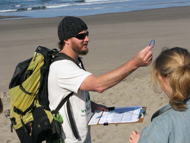
It’s early on a weekday morning, and Chris Pincetich is sifting through a small pile of debris on Stinson Beach. He’s at the high-water mark, called the wrack line. That’s where buoyant ocean flotsam gets stuck as the tide goes out. As we walk along, he stops and points out how plastic strapping looks a lot like weathered eelgrass. Pincetich isn’t your ordinary beachcomber. He’s a scientist trying to compile a local data set for a global problem: marine plastic pollution.

Cargo Ships Keep Bringing Invasives to the Bay

 • 

A recent study has proven the obvious: San Francisco Bay is a major conduit for invasive species. And the biggest culprit? Cargo ships and their ballast water. Environmentalists are now pushing for new treatment requirements to stem the tide of alien species.

How Sausal Creek made Oakland

 • 

How do you develop a booming Oakland when there’s a big creek in your way? Bury it underground, cement it over, channel it with culverts, and turn it into a gravel quarry. Sounds like a plan, right?Sausal Creek has undoubtedly taken a lot of abuse. But one thing must be said: Oakland owes much of its economy to the roughly 3-mile creek that meanders from its headwaters in the Oakland Hills to the San Francisco Bay.

Reclaiming the Richmond Shoreline

 • 

At the northwestern edge of Richmond, near Point Pinole Regional Shoreline, a modest bayshore wetland stands ready to emerge from decades of neglect. Thanks to the residents of nearby Parchester Village and staff of the East Bay Regional Park District, Breuner Marsh will become precious public recreation land and a refuge for sensitive species imperiled by sea level rise.

Japanese tsunami debris arriving, but not a deluge

 • 

It’s been just over a year since the devastating earthquake and tsunami wiped away coastal towns in Japan. As communities rebuild and mourn the loss of loved ones, a portion of the 25 million tons of wreckage is now swirling around the ocean and making its way to California shores.It’s a unique research opportunity for scientists who have never before seen such a sudden, massive deposit of ocean debris from a one-time event.

SF Bay Model reopens after facelift

 • 

The San Francisco Bay model is running wet again, now that the dust has settled on a nearly 2-year renovation project. The scale replica of the bay and Sacramento-San Joaquin River delta system has been largely out of the public eye — and dry — as construction crews upgraded the building and installed new exhibits and solar panels. Now, the U.S. Army Corps of Engineers, which runs the 1.5 acre model on a sea-front building in Sausalito, is welcoming visitors again, starting with a grand re-opening celebration on Saturday.

Keeping Clapper Rails High and Dry

 • 

New artificial islands at Oakland’s Arrowhead Marsh provide some welcome refuge for endangered clapper rails. But can they be expanded into enough other habitats to keep the birds safe from rising sea levels?

Taking the Measure of Climate Change At Corte Madera Marsh

 • 

To launch our new series on climate change in the Bay Area, we follow a group of researchers as they scan the bottom, poke the mud, and gauge the tides at Marin’s Corte Madera Marsh, in the first comprehensive, interdisciplinary effort to understand how the Bay Area’s tidal wetlands will respond to rising sea levels.

Steering the Ship of Wetlands Conservation

 • 

Beth Huning’s current position as Coordinator of the San Francisco Bay Joint Venture isn’t her first role in the field of wetlands conservation, but it certainly is one that brings together her passion for birds, her commitment to environmental protection, and her ability to work well with people representing many different constituencies. That’s essential when running a consortium of over 26 groups focused on San Francisco Bay’s tidal wetlands. Just this month the Joint Venture celebrated its 15th anniversary.

Construction Begins on Largest Restoration in San Pablo Bay Refuge

 • 

At first glance, Cullinan Ranch isn’t much to look at. Bound by Dutchman Slough to the north and Highway 37 to the south, the Solano County property consists of 1,500 acres of low-lying fields. But this former farmland is about to become the largest restored marsh in the San Pablo Bay National Wildlife Refuge.